No high wind concerns at this time. Monday and Tuesday morning, some snow is expected down to between 3500-4000'. Tuesday afternoon through Sunday Nov 28, snow is not expected over the passes at this time. Check road conditions at tripcheck.com
CASCADE PASSES: an insignificant amount, 1-3" is expected 8pm Monday evening through late morning or early afternoon on Tuesday.
NORTH: I-5 at the WA/OR border and northward through Washington is not expected to have snow impacts through Sunday Nov 28.
SOUTH: I-5 at the CA/OR border will have snow flurries or a dusting over the border pass mainly after 9pm Monday to sunrise Tuesday. This will be an insignificant amount and is unlikely to have any major impacts on travel. Tuesday afternoon through Sunday Nov 28, snow is not expected at pass levels (at this time).
Major storms are not expected through Sunday Nov 28. Three moderate to strong strength storm systems will affect the region. Dense fog will be possible at times through Wednesday morning. Frost is possible Monday morning, Wednesday morning, and Thursday morning. Patchy ice will be possible on some of the roads and bridges.
System #1: Later Monday, rain developing after 5:00pm. Tuesday will have some showers during the morning, with just isolated showers lingering through the afternoon. Total rainfall ~1/4". No wind concerns (under 20 mph). Dry Tuesday night and Wednesday.
Systems #2 and #3: Periods of rain and showers will develop Thursday morning (Thanksgiving Day) and continue through Sunday evening Nov 28. Thanksgiving day itself is expected to have 3/4-1" of rain. Some showers on Friday. More steady rain again Friday night through Saturday morning (another 1/2-1"). Light rain/showers on Sunday (Nov 28). Southerly winds can gust up to 20-30 mph at times (especially on Thanksgiving and Sat-Sun).
Looking ahead: Keeping an eye on later Monday Nov 29 and Tuesday Nov 30, as some preliminary data suggests a strong and windy storm may affect the region.
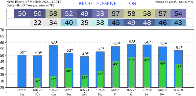
Temperatures look like this over the next 10-days: