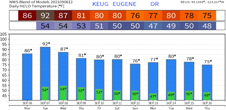
Although it's been ridiculously hot, high temperatures have stayed well below the past week's records of 95-103. Moving forward, record high temperatures gradually lower and eventually drop into the mid-upper 80's beginning Sept 28. Our normal high/low temperature right now is near 81/49. In a post later this week, I'll give an update on the prospects of another La Nina and what the fall-winter temperature/precipitation outlooks are showing.
Rain? The cut-off low pressure system that I mentioned in the previous post is still expected to clip our area as it heads north/northeast from its current position offshore of California, but it has little moisture attached to it. However, there's a small window for isolated light shower chances, from about 7pm Tuesday to 7am Wednesday. Enough instability will also exist for a very small chance of a thunderstorm. Humidity will increase today and Tuesday.
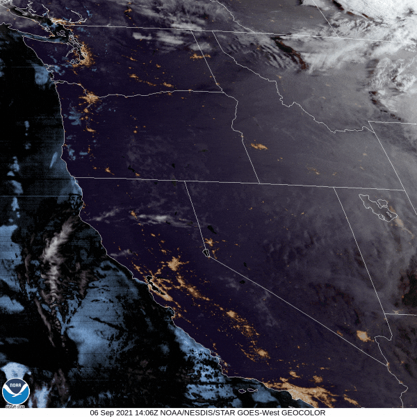
Smoke: Late last week, winds shifted and blew from an easterly direction and brought lots of smoke into the area. Winds then changed to a more "westerly" direction later Saturday morning and it became much less smoky. However, shifting winds today (Monday) and Tuesday will once again bring a bit more smoke into the area at times. Current satellite imagery shows smoke blowing from east to west:

Cooler temperatures on the way!
It looks like Tuesday will be the hottest of the next 10 days (highs mid 80's-near 90 today, around 90-low 90's Tuesday, mid-upper 80's Wednesday). Cooler temperatures are then likely Thursday into next week: Highs in the mid 70's to around 80, lows low-mid 40's. This will be much closer to our "normal" high/low of 81/49.
Getting back to rain...
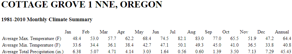
Except for small shower chances Tuesday evening into early Wednesday morning, dry weather is generally favored for the next 10-14 days. However, the tail end of a system to our north may clip our area Thursday evening. At this time it looks dry this far south, but don't be surprised if isolated shower chances pop up for Thursday evening/night. Normal rainfall for the entire month of September is 1.39". As of the time of this writing, it appears that we may not see our first real rain of the fall season until around Sept 20 (or later).
The water year ends on September 30. Since Oct 1, 2020 we've had 33.57" of rain. Normal precipitation for the water year is 45.43", so we're running at nearly a 12" deficit! Lots of strong high pressure across the west and over the North Pacific has kept the jet stream pushed well north of us, into southern Canada. High pressure of this magnitude is very hard to break down or budge much between late spring and early fall. This is because there's less contrast of colder air to the north and warmer air to the south. The jet stream is also "slower" during this part of the year, but begins to ramp up during fall as that contrast increases between cold air to the north and warm air to the south.