Sunday 7:00pm: Cold front and associated colder air is swinging through a little faster than predicted which means snow levels can dip to as low as 500' in spots if conditions align just right here in Cottage Grove. 6:00pm temperature in Eugene is 34° (there were reports of flakes and a dusting in a few spots). Temperature here (at 6pm) is 42° and is currently too warm for snow. However, the temperature will drop as the evening and night wears on. IF we reach 33-34°, some flakes or a light dusting is possible. Computer models suggest an inch if the temperature can drop enough. Note that the bulk of moisture has now passed so any snow that does fall will be light and may not stick.
Scattered light showers on Monday (snow threat ends by 8:00am). Isolated light showers on Tuesday. Probably dry on Wednesday. Thursday and Friday look dry at this time. Next Saturday and Sunday the pendulum leans towards dry but there's a system that will pass to our south and could spin some moisture up our way.
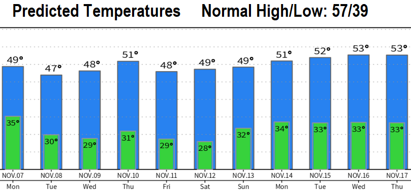
This week will also have the coldest temperatures of the season so far with freezing and below freezing lows expected Monday night through Friday night. High temps 44-50.We've received 1.16" of rain so far from this storm (as of 6pm). Coupled with the two other storms this month, we're now at 4.00" of rain for November. We had 1.48" for all of October. Since the start of the water year on Oct 1, we've recorded 5.48" of rain here in CG. Normal to date is 4.83" so we're still behind and the long range data shows us more dry than wet over the next 10-14 days unless something drastically changes.