Update on Fires, Smoke, Heat; cooling trend starts Thursday!
August 14, 2023
CURRENT FIRES POSE NO THREAT TO COTTAGE GROVE
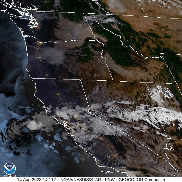
SMOKE: Play the satellite image and you'll see the three fires that are currently burning to our east/northeast: The Lookout Fire, Bedrock Fire, and Salmon Fire. By far, the Bedrock fire is the largest at almost 20,000 acres right now (the other two are 300 acres or less). As you see in the animated image, smoke is blowing FROM the EAST and TO the WEST. That's why our local area is smoky with even some bits of ash falling.
WINDS will shift around over the next few days and blow from varying directions. This will result in differing amounts of smoke being blown into our area at times.
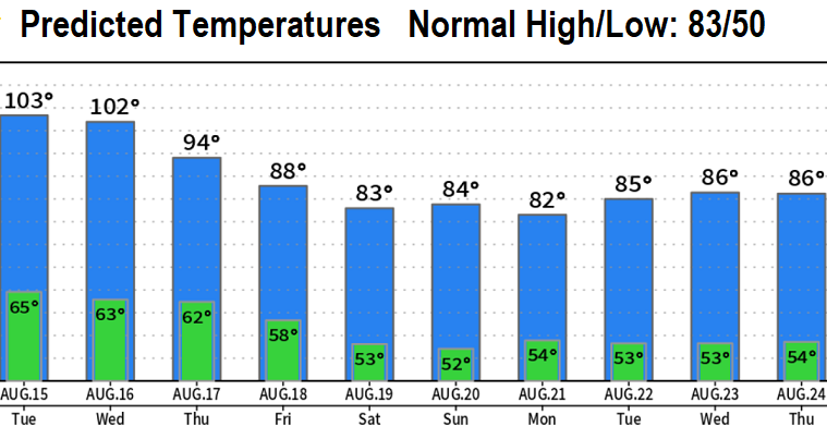
HEAT: As of 1:15pm today (Monday), we've already at 96°. We may reach 103-106, but the smoky skies may not allow high temps to climb above 100/101. Either way, it's hot AND HUMID which means the heat index (how it feels on our body) is running a little bit warmer.
TEMPERATURES: Today through Wednesday will be the hottest days of the week, then we'll cool down beginning Thursday and (fingers crossed) be in the low-mid 80's Saturday and Sunday. At this time, I'm not seeing signals of another heatwave after this week, so there's a good chance (but not 100%) that high temps for the rest of the month from the weekend onward should have highs 90° or below.
SATURDAY PATTERN CHANGE: A low pressure system or two is expected to affect the region and bring some showers and possible thunderstorms (mainly mountains). This may continue into early next week. We'll talk more about this on Thursday.
Subscribe to receive updates when we post weather and preparedness updates to our blog. You can elect immediate, daily, or weekly emails. We anticipate a fairly low volume - 3 to 5 posts per week.