Unsettled into early next week, then dry & warmer?
May 4, 2023
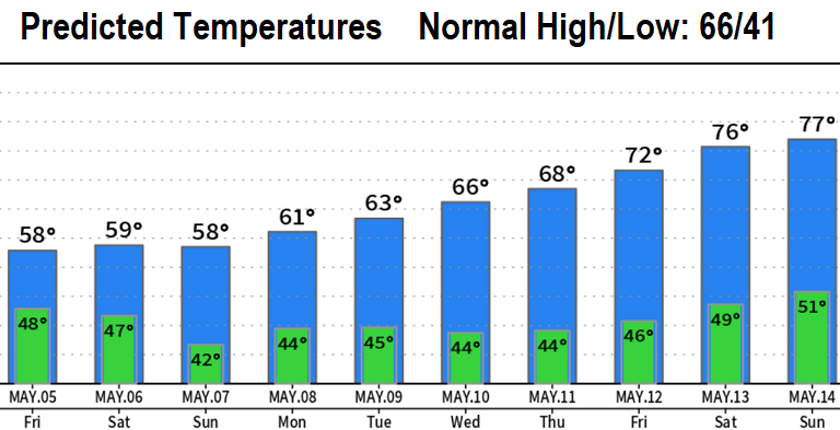
It's hard to believe that just six days ago (Fri Apr 28) our high temp was 93°! In Mother Nature's defense, this is the time of year where temperatures roller coaster (especially highs). Check out the 10-day temperature chart below and you'll see that next week is expected to have a nice warming trend.
A series of four relatively weak low pressure systems will affect the entire region through Tuesday of next week. This will cause scattered to numerous showers through Sunday afternoon, totaling about 1/4" (preliminary). Sunday evening into Monday morning looks like we'll have light rain, adding about another 1/4" to the rain bucket. Breezes will mostly be light with gusts up to 10 or 15 mph at times (no biggie). Sunday evening and night, winds could gust up to 15-20 mph at times (again, no biggie).
Can't rule out a thunderstorm through Tuesday.
Snow levels will vary at 4500-6000' through Saturday, 3500-4500' on Sunday, then 4000-5000'+ early next week. Heavy snow is not expected.
Right now, odds favor our weather to be more dry than not from the end of next week through the middle of May. This doesn't mean that there won't be a few weak storms passing through, bringing some light showers at times, but rather probability odds favor above normal temperatures (as a whole) with below normal precipitation. Also, there's some signals that a typical wet pattern for this time of year may kick in around May 15 or so (very preliminary). Regarding rainfall, we normally see 2.60" for the entire month of May. So far we've had 0.06" with about another 1/2" expected through May 14 (most of this occurring through Tuesday).
Subscribe to receive updates when we post weather and preparedness updates to our blog. You can elect immediate, daily, or weekly emails. We anticipate a fairly low volume - 3 to 5 posts per week.