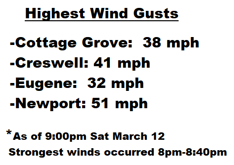
Wednesday March 16: The observed peak wind gusts during Saturday evening's wind storm are accurate recordings of the wind speed. I know it seems like the winds were stronger, but keep this in mind: 1) The wind direction was more from the west instead of south when the strongest winds occurred; 2) Normally when we have windy storms, winds are from the south; 3) Strongest winds were mostly blowing from the WEST. Because we're not used to experiencing strong winds come from the WEST, it sounded different when blowing against buildings and there were more damaged trees than if the winds had otherwise blew from the south (our normal wind direction during storms); 4) Many trees now have leaves coming in when just a few weeks ago they were bare.

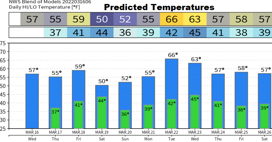
Dry today, then just a small chance of a couple of light showers later Thursday afternoon and evening as the tail end of a weak storm system to our north clips our area. Light winds. St. Patrick's Day is tomorrow, don't forget to wear green!
Friday will be dry to about 8:00pm, then rain develops and will continue through Saturday morning. Showers Saturday afternoon through early night. Winds under 20 mph. Sunday and Monday both look dry right now. A couple of storm systems may affect the area around the middle of next week. These may be windy. I'll post updates as better data comes in.
Normal high/low temperature: 58/36. Since the start of the water year on October 1, we've recorded 27.75" of precipitation. Normal to date is 32.42". Sunrise/Sunset: 7:21am, 7:20pm. Vernal (Spring) Equinox is on Sunday.