Sunday Feb 13: Normal high temp on April 1 is 60 and climbs to 65 by May 1. But the calendar says we're in February! ONE MONTH AWAY- clocks SPRINGING FORWARD on March 13! Light rain should begin Monday around 5:00am then change over to scattered showers after about 10:00am. Showers may linger to about mid-morning on Tuesday. Looks like 1/3" or less of total rainfall, Snow levels above 2500'. Breezy at times on Monday to sunset with wind gusts of 10-20 mph. Dry Tuesday night to Saturday. Another system may bring some light rain on Saturday night. Our region of the snow pack is at 104% of average and Cottage Grove's precipitation is at 23.85" (normal to date is 27.02").
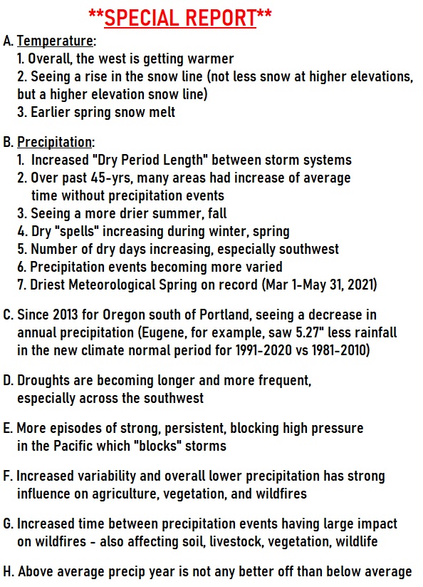
For a while, it was looking like the storm door would open wide starting next weekend. However, the latest data trends are struggling with the strong and anomalous high pressure in the North Pacific that's just pushing the jet stream well north of our area. Over the past 9-10 years, we're seeing this happen more and more during mid-winter and spring (strong, anomalous high pressure in parts of the North Pacific that blocks storms). This is affecting precipitation patterns across the west and is also a major contributor to extended dry periods and drought. I have to note that La Nina has also been affecting the climate this year. See the summary of my Special Report I did last year. THAT SAID, there's some signals that we may be in for a very wet March.