WHAT: A series of three low pressure systems will affect the entire region Saturday through the end of next week. Although there's a chance of showers on Saturday and Sunday, the heavier and more steady rain is expected to move in sometime between late Sunday morning and Sunday evening (this is because the storm system may stall a little bit at the coast or just offshore).
HOW MUCH RAIN: Total combined rainfall amounts Saturday through Friday of next week will be 1-2". Heaviest occurs Sunday afternoon or evening through Monday evening or night (approx 1"). Tuesday through Friday will have periods of rain and showers, which means there will be some dry breaks with isolated showers. Days with least amount of rainfall looks to be Tuesday, Thursday, and Friday before another system moves in late next Friday night (details on this storm will be more clearer over the next several days).
WIND: Gusts up to 25 mph are likely, with the strongest winds occurring Sunday afternoon through Monday afternoon and again on Tuesday. Can't rule out a gust to 30 mph. Since the ground is dry and this will be the first major rainfall event of the season, it's unlikely that any trees will be blown over. At the coast, wind speeds could approach 45+ mph.
SNOW LEVELS: These are not cold systems, so snow levels will fluctuate mainly at 7000-9000'. Passes should remain snow-free.
DROUGHT: Worsened over the past week. Precipitation over the next week will undoubtedly help with the drought and we'll probably see some improvement with next Thursday's update of the Drought Monitor. However, don't expect significant improvement - we'll see gradual improvement over the next several months as more precipitation occurs.
OUTLOOK AHEAD: At this time it looks like the storm door may remain open through at least the first week of October. Not a slam-dunk, but I do see signals that high pressure may not build in and otherwise block storm systems aimed at the PacNW. That said, it won't rain all the time and there will certainly be some dry breaks in between storm systems.
FIRES: The aforementioned storm systems will undoubtedly make a significant dent in the largest fires and possibly extinguish the smaller ones if we get the projected rainfall. If the storm door does continue to remain open through the first week of October AND we get decent rainfall from the additional storms, the larger fires may be reduced to just a smolder and eventually extinguished.
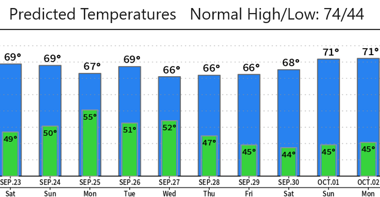
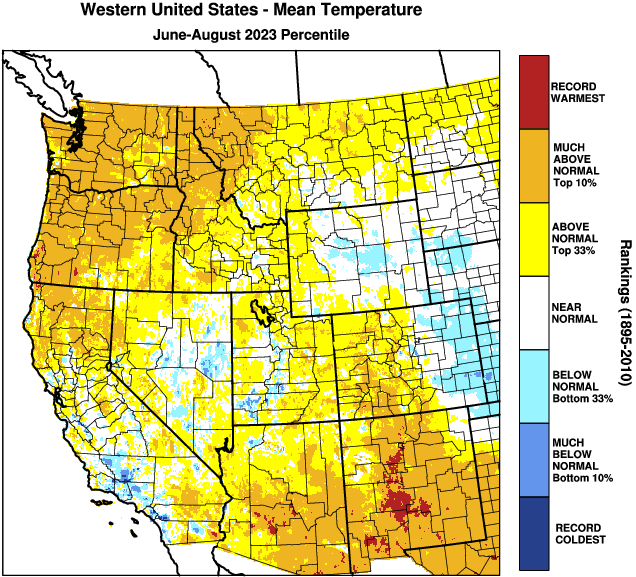
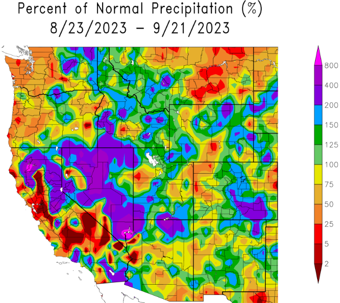
Scroll down and check out the data charts - see how we trended with precipitation and temperature during the summer months (June, July, August).
Subscribe to receive updates when we post weather and preparedness updates to our blog. You can elect immediate, daily, or weekly emails. We anticipate a fairly low volume - 3 to 5 posts per week.