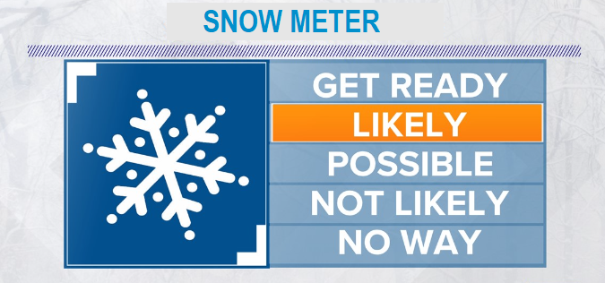
Two very cold back-to-back storm systems will affect the region through Thursday, then another chance for snow possibly Sunday and Monday. There's been some changes with computer model data that creates uncertainties with snow amounts here. Current spread of possibilities is 1-8", but the 4:00pm updated data suite suggests 1-4" more likely (but not 100%). The best timing for most of the snow to fall is Tuesday night through Thursday morning with the bullseye for the most snowfall being early Wednesday morning through Wednesday night. I do need to note that there does exist an extremely very small chance that we can see up to a foot of snow IF the moisture and cold air align just right. NO NEED TO WORRY OR STRESS, snowmageddon unlikely. Remember, for us to get any snow at all, ingredients need to align just right.
In the Cascades, two feet or more of snow is expected. We need it, since our region of the snowpack is sitting at 89% of average to date. By the way, we've only recorded 17.62" of rainfall since the start of the water year on Oct 1. Normal to date is 28.68", so we're behind by 10+ inches. Not what we want to see since our wettest months are now behind us. By the way, 70% of Oregon remains in a drought. Unless we see an abnormally and very wet Spring, drought will only worsen.
WINDS can gust up to 20-30 mph at times.
Temperatures will be very cold. Highs 36-41 Tue-Fri. Lows near 30 Tuesday night, low 20's Wednesday night, near 15 Thursday night, near 15 again Friday night, then mid 20's Saturday night.
HAZARDS will include icy roads / pavement (mainly nights/mornings) Tuesday night through Sunday morning. Remember your pets, they will be unable to maintain their body warmth outside.