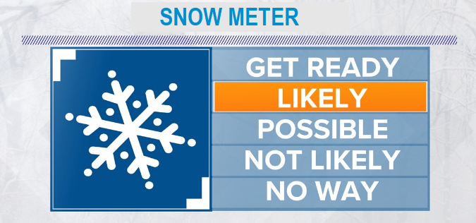
SNOW: Two storms will affect us to about 9am tomorrow. Total snowfall ranges from a dusting to 3-4” with isolated spots of 5” or so. The reason for a wide range is that snow isn't expected to be uniform because precipitation will be "scattered" (some spots get more, some spots less). So it's impossible to predict exactly where the "scattered" precipitation will occur. Best chances for snow is 7pm this evening to 8am Tuesday, with the bullseye between midnight and 8am.
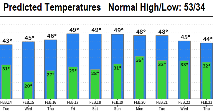
More Details: Cold front from system #1 passed through around 8:30 this morning. Cold air has since been moving in. Expect scattered showers today, with isolated hail and even a rumble of thunder. Heavier showers this afternoon and evening can push colder air to the ground and briefly lower snow levels to 500'. There may be a break in precipitation 9pm-midnight. Winds through this evening can gust up to 10-20 mph at times in spots. System #2 arrives around midnight. With cold air already in place, snow levels down to 500' will be possible midnight to 7/8am Tuesday. Icy roads/pavement likely Tuesday morning and again Wednesday morning. Very cold Tuesday night with lows 15-20°, then 19-24° Wednesday night. Below freezing lows expected through Saturday. Dry Tuesday afternoon through at least Friday or Saturday.
Pets left outside will be unable to maintain their body warmth.