
First things first: THIS IS NOT A BMTP EMERGENCY (Bread, Milk, TP)! Snowmageddon highly unlikely, NO Ice Storm. Snow predictions are most accurate within 24 hrs of the event, apps causing unnecessary panic. All ingredients must come together "just right" for it to snow in Cottage Grove. The snow possibilities listed below are how it looks as of the time of this writing (11:30am Sunday).
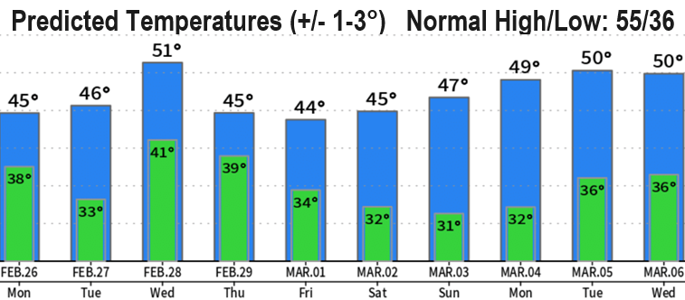
WILL IT SNOW in Cottage Grove? Possibly some flakes Monday night-Tuesday morning (although unlikely, a dusting can't be ruled out but little moisture will be left with the storm). Zero snow chances Tuesday night through Thursday evening. Thursday night-Friday morning, a dusting to 2" possible. Friday night into Saturday morning a dusting to 1" possible but by this time little moisture will be left from the storm.
SNOW LEVELS: Above 4000' today, 2000' tonight, 1200' Monday, 800' Monday night and Tuesday morning. Tuesday afternoon above 1500', 2000-3000' Tuesday evening, Wednesday, and Thursday morning.
WINDS: Windiest days look to be Wednesday-Thursday when we can see wind gusts up to 30 mph. Otherwise, gusts up to 15-20 mph possible at times through Tuesday and on Friday.
RAIN: Expect 2-3" of total rainfall through Saturday morning. No flood concerns at this time.
*NEXT EMAIL UPDATE MONDAY AFTERNOON OR TUESDAY MORNING*