
As the clouds move in your worries have all gone; as the rain falls it will cleanse your tired soul… Quiet weather today (Thursday), but a big change is on the horizon as Fall's first seasonably strong storm affects the entire region later Friday through Sunday. Oh, and enjoy the mild fall daytime temperatures today and Friday because highs will cool into the upper 50's to mid 60's Sat-Sun.
Friday: Humidity, clouds, and wind will gradually increase throughout the day on Friday, signaling that rain will soon arrive. High temperatures will be mild, topping off somewhere between the upper 70's and mid 80's; lows in the low-mid 50's. In the afternoon and evening, it will most likely feel humid and muggy.
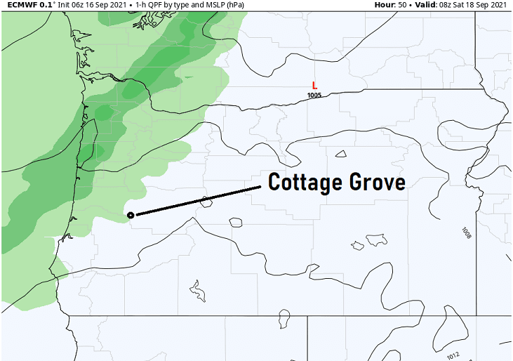
Rain start time: As of the time of this post, rain looks to develop between 9pm Friday and 3am Saturday. Lots of factors are influencing this system which could possibly cause the cold front to slow down or briefly stall, hence the 6-hour window of when to expect the onset of rainfall. Rain may be heavy at times Saturday morning into the early afternoon before changing over to showers. Periods of showers will then continue through Sunday. Lingering isolated light showers may continue on Monday. This particular model indicates rain may start around midnight:
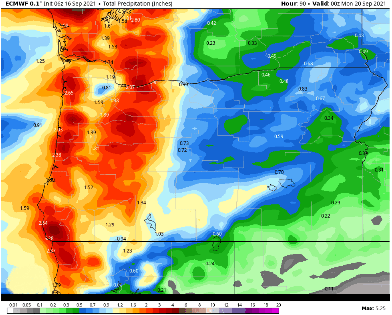
Total Rainfall: Computer models have come into better agreement this morning that total combined rainfall between Friday night and Sunday evening will be around 1" to 1.75" with higher totals in the mountains (2-3"). If the front slows down or stalls, these totals could be a little higher. For September, Cottage Grove's total average rainfall is 1.39". This system will likely give us the entire month's worth in just one dumping! Total rainfall prediction by one of the more accurate models:
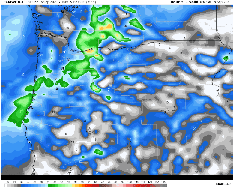
Wind: Although seasonably strong, this is your typical early fall storm (in terms of wind). Winds will gradually increase on Friday, gusting to 15-25 mph Friday afternoon and evening. Peak wind gusts of 30-35 mph are then expected just before the cold front moves through Friday night into Saturday morning. Thereafter, it will be breezy at times with winds gusting up to 15-25 mph through Sunday afternoon. Note it won't be breezy/windy all the time, so expect some lull periods. Here's modeled peak wind gusts (around 30mph for Cottage Grove) as the cold front nears at 1:00am Saturday:
Thunderstorms: Convective parameters favor isolated to possibly scattered thunderstorms between Saturday afternoon and Sunday evening. Highest chances are Saturday 3pm-8pm and Sunday 10am-6pm. Thunderstorms would be capable of producing small hail, gusty winds, and brief heavy downpours (which could add to the predicted rain totals).
Snow: This isn't a particularly cold system, so snow levels will likely remain above 6000-7000' but could briefly lower in a convective shower. Looks like just a dusting to an inch or two at the higher peaks.
Fires/Smoke/Drought: As you would expect, the anticipated 2-3"+ of rainfall over the mountains will have a significant impact on the current fires. Depending on how much rain actually falls over the fires, some of the the smaller fires may be reduced to just a smoldering. Unfortunately, fire burns up vegetation and leaves the ground bare ("burn scar"). Since there's now nothing left to hold water from the rain, heavy rains can cause mud and debris flows as well as flash floods. On Monday, any fires still burning or smoldering would still give off smoke which could still affect the areas at times as winds shift around next week. Regarding drought, we should see at least small decreases of the worst categories when the update comes out next Thursday. There's basically been no changes to the drought index over the past few weeks, so a little improvement from the rain will be welcomed.
Next Storm: May be on Wednesday, but don't hold your breath! Right now it looks like only very light rain (around 1/10"). It's possible that the system may remain too far north to bring us anything. In any case, after this weekend's storm and except for Wednesday, the rest of the month looks dry. Disclaimer: Forecast accuracy largely decreases beyond 5-days and is very low accuracy after 10-days.