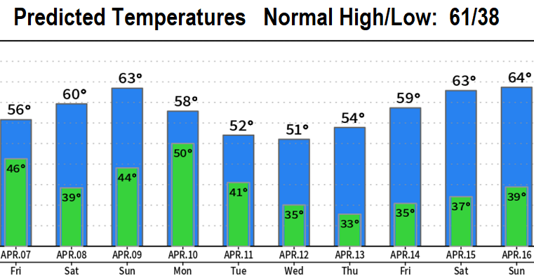
As of 5:00pm Thursday: Rain/showers will continue through early Friday morning, then will be isolated to scattered during the day and end by sunset. Total rainfall through tomorrow 1/2" or less. Although a few wind gusts up to 20 mph could sneak in before midnight, winds overall are expected to be light.
Saturday still looks to be dry. Easter Sunday: a big question mark. Although a few light showers are possible as early as 9:00am Sunday morning, chances for light rain increase during the late morning or early afternoon. I should note that the latest data coming in is hinting at the Easter Sunday low pressure system slowing down a bit before fully moving inland. Therefore, the bulk of rain on Sunday may actually not occur until mid/late afternoon or perhaps evening - if the system briefly stalls. At this time, I'm leaning towards the storm stalling for a bit with a later onset of rain on Sunday. Basically, a chance of showers Sunday morning/afternoon with rain developing sometime during the late afternoon or evening. No wind concerns - gusts 15 mph or less.
Monday, rain continues. Showers on Tuesday. Isolated showers on Wednesday. At this time, there's strong signals that late next week into the following weekend may be dry with seasonably mild temperatures.
Snow levels: Above 5000' today, above 4000' Friday, then above 5000' Saturday through Monday.