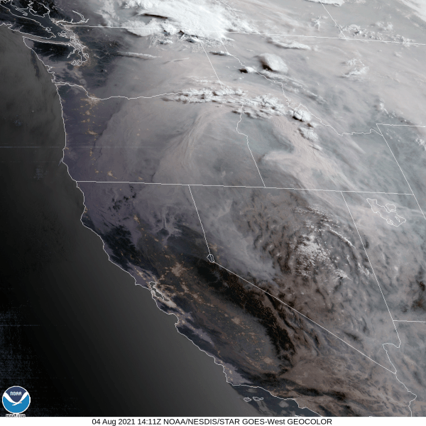
Today's been hazy with smoke filled skies across the area. Satellite imagery clearly shows the smoke being drawn north into the state from the fires in Northern California. I don't know of anyone who's enjoying the heat and humidity (and I'm sure you don't either). For quite some time now, our region has been on the western or northwestern periphery of strong high pressure that's been parked over the desert southwest. At times, this high pressure has expanded north, stretching westward from the Rocky Mountains of Colorado. Circulation around high pressure is "clockwise." Since we've been more/less on the western periphery of this high pressure for many weeks now, this has resulted in warmer, humid air and some monsoon moisture being transported north into western Oregon within the "clockwise" flow. Looking at the seasonal average temperature trends since the Memorial Day holiday weekend, our highs have been above average 75% of the time with lows also running above average at about 60% during the same period.
Several weak low pressure systems will begin affecting the area early Thursday morning through Sunday. Under varying amounts of clouds, the main impact will be relatively cooler temperatures (highs ranging from the mid 70's to low 80's, lows fluctuating between the low 50's to near 60). As these low pressure systems pass through the region, light showers will be possible at times (best chances Thursday morning-afternoon and Friday morning-afternoon). Can't rule out a few rumbles of thunder, especially Thursday. Also, as each system passes through, don't be surprised to see some wind gusts up to 15 or 20 mph at times. Otherwise, winds should mostly be 10 mph or less. This will "freshen" the air a little and help mix out some of the smoke.
Combined rainfall amounts will be light, totaling at less than 1/10" (0.10") with many spots probably receiving only 0.01-0.07". However, these totals could be higher if a thunderstorm passes through. Some spots across the region may not receive anything more than some sprinkles. Again, Thursday and Friday have the best chances for light showers.
Heat Returns Next Week?
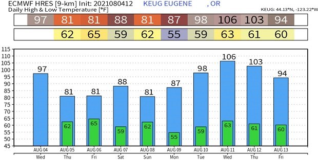
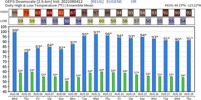
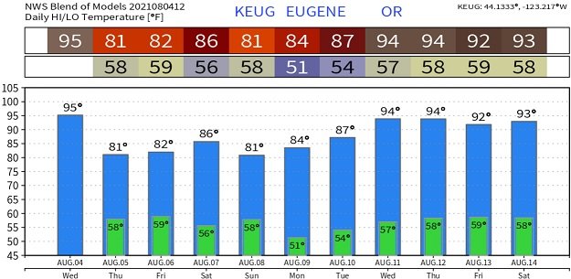
Most data now indicate that high pressure may begin building back into our area towards the middle of next week. If this comes to fruition as modeled, temperatures next Wednesday and Thursday (Aug 11/12) could jump into the mid and possibly upper 90's. Below, take a look at the various temperature trends predicted by some of the models. Note the 106-degree prediction, which is being "discarded" as an "outlier model" right now. Lets see how the pattern goes over the next 2-3 days before we get frustrated about the possibility of ridiculous heat returning next week. Who's ready for fall?