Tuesday Weather Update: Enjoy the sunshine this week!
Record/near record temperatures on Friday, a little cooler Saturday, then much cooler Sunday! High pressure is in control of the west so we'll be dry with a gradual warming trend this week. Check this out - our LOW temps later this week will be near 50, which is what our high was just 5 days ago!
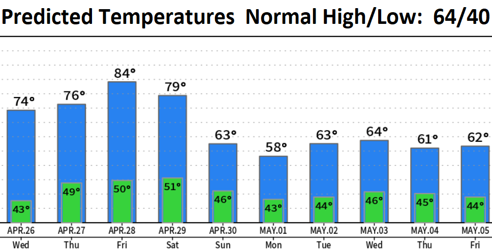
Sunday/Monday a weak low pressure system will cause high temps to drop by 15-20 degrees from that of Fri/Sat. This system may also bring some sprinkles or a light shower or two, but not worth canceling any outdoor plans (Sun/Mon). Latest signals right now are that the storm door may open wide starting around May 5. Near normal precip is expected for all of May (which totals 2.60" for the month). Temperatures should trend near to slightly below normal (for May, as a whole). By the way, statewide snow pack varies at 165-200% of average. Our region, the Willamette Basin, is at 200%! Looking at drought, 56% of the state is still in a drought and that number likely won't improve much (if any) over the next 45 days.
Note about records: Eugene is our closest "official climate station" which means that there's a consistent set of data over a long period of time at the same spot. For Cottage Grove, we do have data from 1916-2016 but there's large enough gaps (missing data) so we can't use this data in determining "official" records. Therefore, for situational awareness and to give us a general perspective of temperature records, we reference Eugene's. Eugene's Record Daily High Temp for Friday is 83 set back in 1968. For the entire month of April, Eugene's Record Monthly All-time High Temp (April) is 89 set back on April 28, 1926.