Rain & Showers this week + are we done with the heat?
August 27, 2023
Fall-like pattern finally kicks in this week! Meteorological fall begins on September 1; Astronomical Fall (Autumnal Equinox) occurs on Sept 22 at 11:50pm local time.
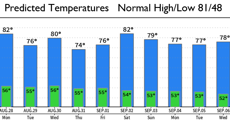
TEMPERATURES: High temps will be AT or BELOW the normal of 81 over the next 10+ days (varying between about 72-82). Lows will be 2-5 deg above the normal of 48. In fact, it may be a struggle to reach 80 from Sunday onward. If you think it's been a long, hot summer, you're not wrong. High temperatures from June 28 through August 17 were above normal (with the exception of a day or two here and there).
RAIN THIS WEEK: A weak storm system will bring a chance of light showers Monday night through Tuesday night; expect less than 1/10" total. A stronger storm is then expected to bring widespread rain to the entire region on Thursday and possibly some light showers on Fri/Sat. Preliminarily, looks like Thursday's system may bring 1/4-1/2" of total rainfall and some breezes to the area. This will HELP but NOT PUT OUT the major fires that are burning. Additional storms are expected next week (all look weak at this time with light shower chances).
FIRES/SMOKE: There's four major fires burning throughout the western half of Oregon (all to the south, east, and north of us). Winds ARE expected to blow more from the west this week and bring more refreshing marine air into our area from the west. I should note that the wind direction will still shift around at times and could still blow smoke into our area (however I expect this to be the exception, not the rule).
EL NINO - PRECIPITATION: El Nino conditions are present across the Equatorial Pacific. El Nino has four strengths (weak, moderate, strong, very strong). Each strength typically causes different impacts across the PacNW and West Coast. The latest data strongly favors El Nino peaking in the "strong" category between October or November and March. Since 1950, there's only been two "strong" El Ninos - 1987-88 and 1991-92. Based only on these two events, Oregon had 70-110% of normal rainfall during the 1987-88 strong El Nino and had 40-90% of normal rainfall during the 1991-92 strong El Nino. This DOESN'T mean that we'll experience the same this winter as to the previous two strong El Nino events because 1) records for La Nina / El Nino only start at 1950, and 2) there are not enough "strong" events on record to be able to form any type of scientific conclusion. Therefore, we cannot rely on just these two "strong" events to say yay or nay to what we may see this winter, precipitation wise.
EL NINO - TEMPERATURES: Oregon experienced below normal temperatures of -5 to -10 (as a whole Dec-Feb) during both "strong" El Nino occurrences on record. Again, as stated above, there's not enough recorded "strong" El Nino events to form any sort of scientific conclusion as to which way the pendulum will swing.
Subscribe to receive updates when we post weather and preparedness updates to our blog. You can elect immediate, daily, or weekly emails. We anticipate a fairly low volume - 3 to 5 posts per week.