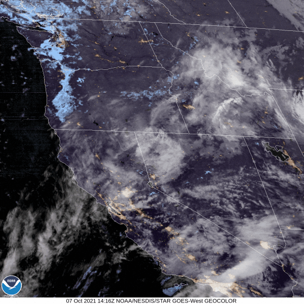
Night/morning fog remains possible again tonight and Friday morning, but frost is not expected. There'll be a slow increase of mainly high clouds overnight ahead of the next weak storm system that may bring some light showers to the area later Friday afternoon to early night (but don't hold your breath). Very light winds may also switch to southerly during the predawn hours (coldest part of the night). This combination is unfavorable for frost development, although lows tonight will still have the potential to bottom out at around 37-40. As you'll see in this morning's satellite imagery, the entire Willamette Valley is socked in with stratus and fog (expected to burn off during the afternoon).
Friday-Saturday: With the exception of a small chance of some light showers later Friday afternoon into the early night, dry weather will continue through Saturday evening. Total rainfall with this system will be zero to 1/10". Snow levels 5500-6000', a dusting to an inch at the highest elevations. Partly to mostly cloudy skies on Friday then mainly clear to partly clouds on Saturday. No wind concerns - light at around 10 mph or less.
Sunday-Monday: The next storm system, colder and medium strength, moves into the area Saturday evening or night. As it looks right now, light rain will develop between 10pm Saturday night and 4am early Sunday morning. Total rainfall through Monday looks to be around 1/5-1/3" (0.20-0.33"). Snow levels start out at above 7000' Saturday night, but gradually lower throughout the day on Sunday. Sunday night, snow levels will further lower to between 3800-4200', then vary between about 3800-4500' on Monday.
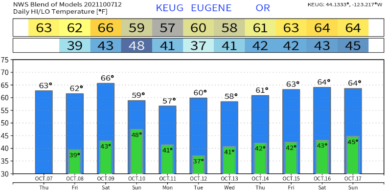
Tuesday-Friday: Uncertainty exists, as there's enough disagreement with the computer models that throws some doubt into the strength and timing of low pressure systems affecting the region next week. Therefore, based on current data, Tue-Fri looks to be unsettled at times with only small chances of light rain or showers - mainly on Wednesday and Friday. Right now, total combined rainfall Tue-Fri looks to be 1/4" or less. This may change in the coming days as data becomes more refined. Next week will also be cooler than normal - highs in the mid 50's to low 60's, lows mid or upper 30's to low 40's (normal high/low temperatures are around 66 and 42, respectively).
The following weekend onward (Oct 16-31): Saturday Oct 16th looks dry right now, but there continues to be signs that a series of low pressure systems may affect the PacNW region starting on October 17th. Still too early for the details and this could also reverse course, so it's not set in stone. Normal average precipitation for the month of October is 3.67". As of today, Oct 7, we've recorded exactly 1/2" (0.50"). I'm cautiously optimistic that the second half of October will be filled with enough storms so that the month can close out at 75-100% of normal rainfall.
Temperatures look like this over the next 10-days (Cottage Grove's lows will mostly be upper 30's to low 40's, with a couple of days possibly at 35-37):
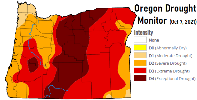
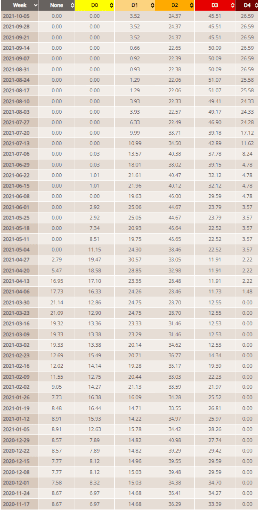
Drought
December 17, 2019 was when Oregon first entered this round of drought. All or portions of the state have been stuck in some level of drought conditions ever since. To give you an idea of how bad the drought is, today's weekly update of the drought monitor shows no improvement over the past three weeks. In other words, the recent rainfall hasn't made much difference in the statewide drought (but keep in mind it's still early, as we're just starting to enter our rainy season). Take a look at the history of the weekly drought monitor, since November 2020. Note that "D0" (abnormally dry) is not an official drought category.