What: A storm system will bring rain and breezy to possibly windy conditions Monday morning and afternoon. Cooler/drier air mass moves in on Monday. Snow levels will be 3000-4000' Monday night and Friday night. Just a dusting to an inch below 4000' during this time period.
Timing: Rain develops around 10am-2pm on Monday. Winds start to pick up around predawn Monday and gradually increase throughout the morning and early afternoon. Winds will decrease late afternoon or early evening on Monday.
Hazards: Wind gusts of 30 mph can break a tree limb or two. High winds are expected to stay confined to the coast.
Total Rainfall: Expect 1/3"-2/3" (0.33-0.66") of total rainfall 11am-11pm Monday. Total average rainfall for the month of November is 6.92". As of 10:00am today (Sun Nov 14), we've recorded 4.03" so far this month and 8.58" since the start of the water year on Oct 1.
Wind: Southerly winds can gust up to 30 mph at times on Monday. Strongest winds 9am-3pm Monday.
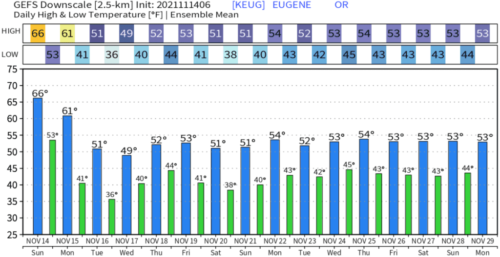
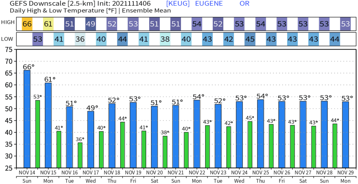
Temperatures (5-days): Much cooler (and drier) air mass moves in on Monday. High temps Monday around 60, then ~50-55 Tuesday through next weekend. Lows: Monday night 33-37 // Tuesday night 29-34 // Wednesday night 33-37 // Thursday night 36-40. Normal high/low is near 53/38.
Fog: Patchy fog possible at times, especially Tuesday and Wednesday.
Snow Potential below 1000': Not going to happen.
Frost/Ice probability: Some frost is possible Tuesday morning. Frost, freezing temperatures, patchy ice on the roads are possible Wednesday morning. Temperatures are expected to be above freezing Wednesday night through the weekend.
15-day Outlook: Dry Tuesday and Wednesday. Next storm system comes in Thursday afternoon, bringing another round of rain and wind gusts to 25 mph. Friday evening through next weekend looks dry at this time. Thanksgiving week, a storm system may affect the area on Monday (Nov 22) with rain and mountain snow. Looks dry Tue-Wed (Nov 23-24). Another storm may affect the region on Thanksgiving Day (Nov 25) and Friday Nov 26. This is very preliminary. Timing will probably change and it should be noted that uncertainties exist from Mon Nov 22 through the Thanksgiving holiday weekend.
Seasonal Outlook (90-days, preliminary): Slightly better chances for near average precipitation, good chances for near normal temperatures for December.
Predicted temperatures look like this over the next couple of weeks: