Snow levels gradually lower through Thursday/Friday. Looks like four storm systems will affect the region between Tuesday night and Dec 16.
Tomorrow (Tuesday): snow levels above 6000'
Wednesday: 3000' (may drop to 2000' at night)
Thursday & Friday: 1800-2200'. May be around 1000' at times Thurs night
Sat-Sun: Above 3000'
Dec 13-20: At this time, colder air is expected to be in place with low pressure systems cold enough to possibly drop snow levels down to somewhere around 800-1200' at times. Lots of uncertainty still, but data has been relatively consistent with cold air coming in with some of the storm systems so this can't be ignored. There's also the possibility that one or two of the systems after Dec 13 may miss us and move south into California.
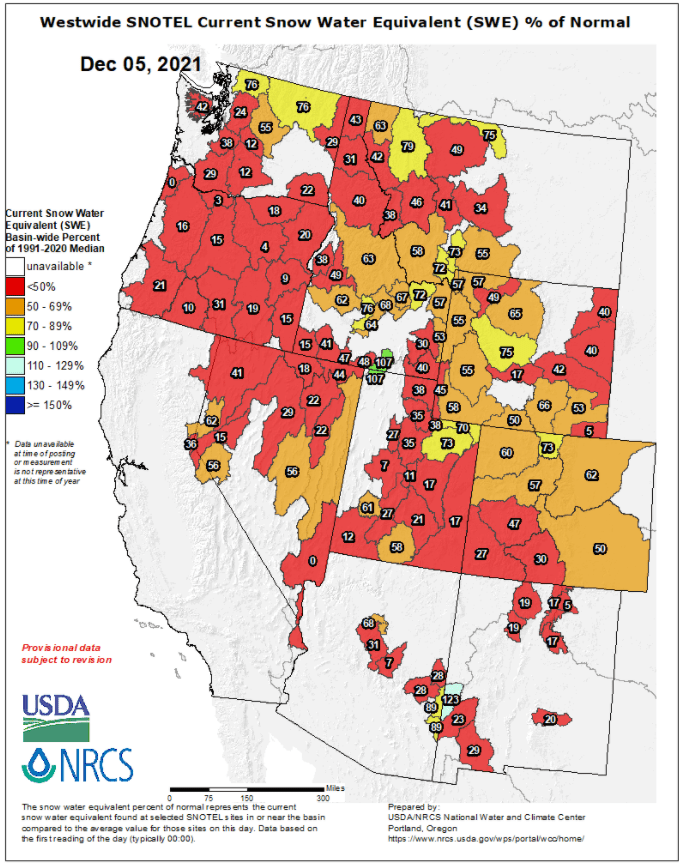
Total combined additional rainfall through early next week looks to be around 1-3" with 3-4 FEET of new snow in parts of the higher Cascades (we need it - see image showing how bad the western snow pack is). 98% of Oregon is still in a drought - it's not going away anytime soon.
As of 4:00pm Mon Dec 6, we've recorded 10.78" of rainfall since the start of the water year on Oct 1. Normal to date is 12.39".
I'll do another post tomorrow with more details.
December 5th western snowpack looks horrible, but with 3-4+ feet of new snow possible over the next 10-days, these numbers will improve (possibly by a significant amount):
Subscribe to receive updates when we post weather and preparedness updates to our blog. You can elect immediate, daily, or weekly emails. We anticipate a fairly low volume - 3 to 5 posts per week.