Predicted snow was a No-Go...well below normal temperatures...more snow chances ahead...
February 23, 2023
UPDATE ON STORM DISAPPOINT:
Yes, my forecast was a bust. For those of you who wanted more snow than the dusting to 1" we got, let's be disappointed together. Here's what happened (nerd hat on):
First, play the GIF image and look for the swirl offshore in the Pacific that starts out west of the OR/WA border and curls / swirls as it slowly moves a little south. See it? That's the pesky low pressure system referred to beginning with #2.
The low pressure system unexpectedly stalled Tuesday night.
"Mini" low pressure systems developed around the main low pressure system. These "mini" low pressure systems are what caused all the snow in Portland yesterday. Typically, these "mini" low pressure systems develop very quickly with little or no notice and therefore causes major havoc with forecasts.
Pretty much all data didn't predict all of this and the computer models were way off through last night. We Meteorologists use the computer models as an aid in forecasting (some only use the models as "the" forecast, I don't). By the way, apps are all automated and only use a particular computer model as its forecast. That's why apps are sometimes polar opposite of what's occurring and are often wrong.
Many of my colleagues and I were thinking that the system wouldn't stall, but when it did we thought it would be brief and then move south through the area yesterday. It didn't. Mother Nature had other plans and the system continued to have a mind of its own.
This also caused winds to not cooperate yesterday, resulting in slightly warmer air across the area. Therefore, snow levels during the day yesterday mostly stayed at or above 1000' with some brief snow showers in Cottage Grove during the day.
Temperatures cooled last night and scattered precipitation was in the form of snow showers that gave us a dusting to an inch here in Cottage Grove. Much less than predicted.
The low pressure system is now finally moving south, currently about 150 miles west of about Tillamook as of the time of this post.
Isolated to scattered showers (hit/miss) today. It's possible that we may get no further precipitation or just a few light showers. A few wind gusts to 15 or 20 mph possible. No biggie.
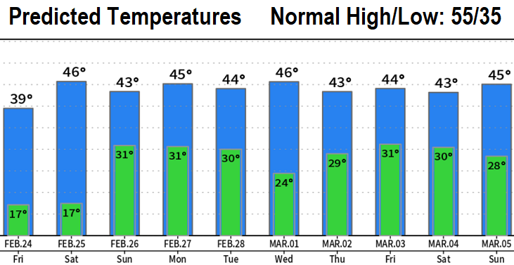
COLD TEMPERATURES: Much below normal! Highs today/Friday around 40, lows tonight/Friday night 15-20. Lows of 28-32 are expected Saturday night through Monday night. Our normal high/low is 55/35.
MORE SNOW CHANCES: Two to three very cold storm systems will affect the region Saturday evening through Wednesday. In Cottage Grove, there's a chance of a dusting to 1" Saturday night into Sunday morning and again Monday night into Tuesday morning. More on this tomorrow. Some wind gusts to around 20 mph, no strong wind concerns. Cold air will be in place all of next week. An additional storm system or two may then pass through March 3-5, with possibly more snow chances.
Subscribe to receive updates when we post weather and preparedness updates to our blog. You can elect immediate, daily, or weekly emails. We anticipate a fairly low volume - 3 to 5 posts per week.