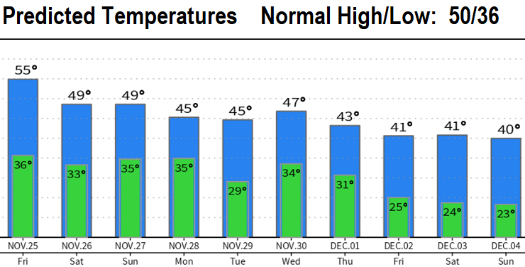
Happy Thanksgiving! Dense fog isn't expected tonight, although could see some fog ahead of a weak storm system will bring some light rain showers to the region from about mid-afternoon Friday through early Friday night. Less than 1/4" of rain with snow levels 4000-5000' (no significant snow over passes). No wind concerns. Dry Saturday, next storm arrives Sunday morning. Snow level 3500' Sunday morning, above 4000' Sunday afternoon, then lowering to 2000' late Sunday night and on Monday (significant snow over the passes possible Sunday evening through Monday morning). Here in CG, less than 1/2" of total rainfall Sun-Mon and no wind concerns. Another cold system looks to pass through on Wednesday-Thursday. MUCH colder air will arrive next week - see temperature chart below.
Regarding snow potential here next week: At this time, best possibility may be next Thursday. Note that snow predictions are most accurate within 24-48 hours. However, no doubt that cold air will again move into the region next week so any cold storm that passes through could drop snow levels to the valley floor - especially next Thursday. Remember apps are automated and largely inaccurate when it comes to snow predictions (sometimes they're right, most times apps are wrong). Stay tuned!