More dry than wet through Saturday, then rainy? La Nina next Fall/Winter?
February 19, 2024
It's Monday and here's how the next 10-days look, weather-wise... It will be more dry than wet through Saturday, then it looks like we'll switch to a wet pattern Sunday through at least March 2nd.
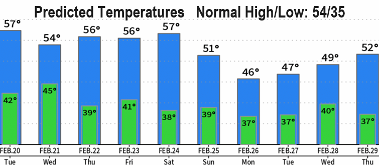
Today through Wednesday will have some showers at times (1/4" or less total), then dry Thursday through Saturday. Today and tonight will also have a small chance of a thunderstorm, which could cause a brief heavy downpour, small hail, and gusty winds. Looking at winds, just a little breezy at times today and Tuesday with gusts 20 mph or less. I don't see anything significant with temperatures, but next week does look a little colder - especially high temps. Normal high/low is 54/35.
Outlooks for March and April lean towards below normal precipitation and above normal temperatures. Keep in mind that this is just an outlook, is preliminary, and can certainly change.
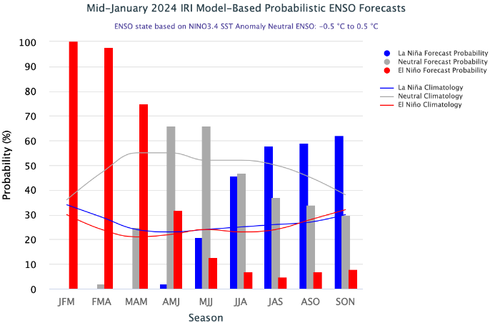
El Nino is expected to dissipate during April/May, then a La Nina may form during the second half of summer and continue through Fall and possibly next Winter (check out the model predictions in the image). When La Nina conditions are present, about 66% of the time Western Oregon experiences above normal precipitation. We'll be talking a lot more about this over the next several months.
Subscribe to receive updates when we post weather and preparedness updates to our blog. You can elect immediate, daily, or weekly emails. We anticipate a fairly low volume - 3 to 5 posts per week.