Last chance for a dusting Wednesday morning then higher snow levels; Spring Forward on Sunday...
March 7, 2023
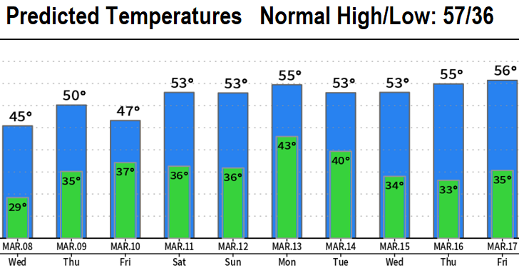
Tuesday 3:45pm Update: Tomorrow morning (Wednesday) looks to be the last chance this week for a light dusting of snow here in Cottage Grove. The chance is small, but a chance nonetheless.
The pesky low pressure system that's been hovering around off the coast the past few days causing scattered showers, low snow levels, and breezes, is expected to slowly move east overhead tonight and Wednesday morning. Scattered showers with some breezes to 15 mph at times will continue through Wednesday. A thunderstorm is also possible through this evening.
As this current storm system exits, another one will take its place later Wednesday through Friday. This system will be stronger, so Friday will be breezy with wind gusts to around 30 mph. Also, the storm will draw up some subtropical moisture, so plenty of rain is a good bet Thursday into Saturday morning. Total rainfall could approach 1-1.50", most of it falling on Friday.
Saturday will have some showers, then periods of rain Sunday through Tuesday. About another inch of total rainfall Sun-Tue.
Snow levels will rise Thursday afternoon and then fluctuate at 2000-3000' through Saturday. Sunday-Tuesday, snow levels further rise to 3000-4000' or higher.
Later next week, another potentially very wet storm system may affect us. Snow levels look to remain above 2000'.
A friend who apparently has nothing better to so sent me the below picture of the "stool bus." Thought I'd share it to hopefully give you a laugh.
Subscribe to receive updates when we post weather and preparedness updates to our blog. You can elect immediate, daily, or weekly emails. We anticipate a fairly low volume - 3 to 5 posts per week.