La Nina:
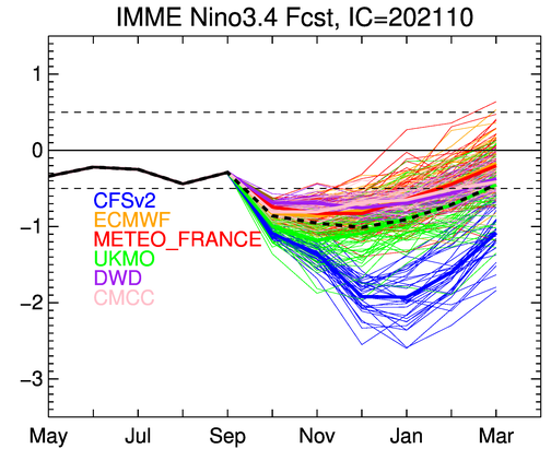
We've been talking a lot about La Nina lately. The latest data updated just yesterday shows that the atmosphere is now "linked" (responding to) La Nina conditions. La Nina has three different strengths, each of which generally have different impacts across the Pacific Northwest and Western Oregon. The majority of data and models signal that this La Nina episode will likely peak at moderate strength. Last year, La Nina peaked in the low end of "moderate," but then quickly slid into "weak" during January. The impact was a much drier spring than normal (Feb-May 2021). Normal precipitation February through March is 16.59", but this year we only recorded 10.28" as La Nina weakened. This represented a 6.31" precipitation deficit for just the period of Feb 1 to May 31, 2021 and was a major contributor of the 2020-21 water year closing out on September 30 at just 80% of normal.
The majority of the models predict La Nina will peak at a borderline weak-moderate episode, with some models leaning strong ( 0 to +/- 0.4 is neutral, -0.5 to -0.9 is weak, -1.0 to -1.4 is moderate, and -1.5 or below is strong):
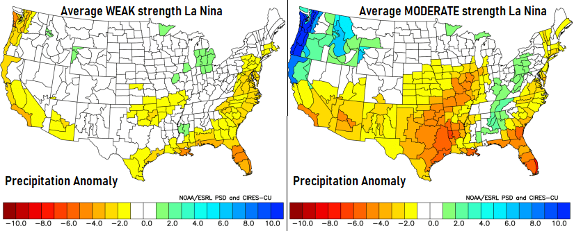
Precipitation anomalies during a weak, moderate strength La Nina (yellows = below average, blues = above average):
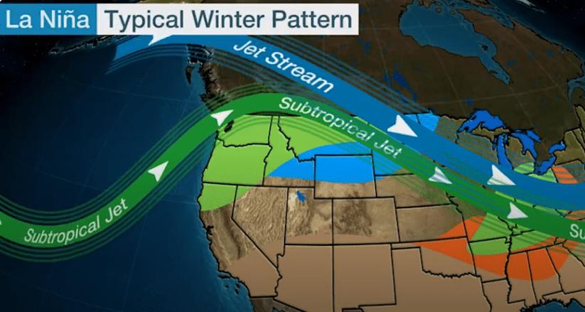
Bottom line with La Nina conditions this fall and winter: Based on how things look right now, precipitation is expected to be around average to slightly above average through May 2022. However, many factors will come into play over the next 6-months which could affect these early season predictions (in one way or the other). Generally speaking, the jet streams during a La Nina pattern look like this (especially during a moderate and strong episode):
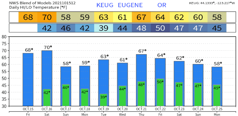
The next 10-16 days (Oct 15-31):
Today and Saturday will be dry with mild daytime temperatures, light to calm winds, and night/morning fog. Clouds will then be on the increase later Saturday afternoon or evening with cooler temperatures and rain developing on Sunday. After a few possible morning showers on Monday, the rest of the day through Tuesday will be dry. Total rainfall on Sunday looks to be 1/2-3/4". Snow levels start out above 6000' on Sunday and lower to 4000' Sunday night. No wind concerns through Tuesday, gusts should stay at or below ~15 mph.
A series of storm systems are expected to bring periods of rain and mountain snow to the region early Wednesday morning through the following weekend (Sat-Sun Oct 23-24). Could see a few wind gusts to 20 mph. Thereafter, the storm door *looks* to remain open with systems regularly passing through right on into Halloween. Some of these systems may be strong. This is too far into the future for exact timing, which will be addressed in my updates. These systems may add another 3"+ of rainfall on top of what we have now (currently at 1.01" for Oct) and what we'll get on Sunday. October may just end up getting more rainfall than the 3.67" average for the month.
Temperatures look like this over the next 10-days: