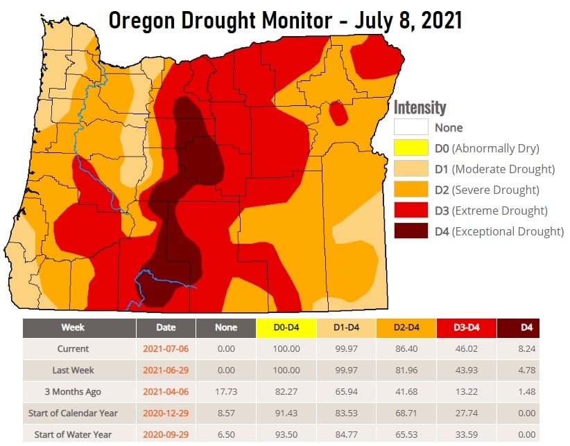
You probably noticed less marine clouds this morning, which means more sun and warmer high temperatures into the mid 80's to low 90's. This will continue through the weekend. Normal high is near 82. I've attached one of the computer model's temperature predictions. Not exact, but it gives an idea on what things *may* look like over the next couple of weeks. Check out the latest Drought Monitor and the satellite image which clearly shows two large fires burning in Oregon. The Jack Fire east of Roseburg (currently near 4300 acres) and the massive Bootleg Fire a little northeast of Klamath Falls (nearing 17,000 acres). When you play the Satellite Image, it starts from about 12:30pm yesterday and runs to 8:45 this morning. Note the smoke yesterday was being blown to the east but after sunrise this morning it's now being blown to the west because the inland winds have shifted due to high pressure strengthening (as noticed by the absence of marine clouds here this morning). Therefore, it's possible a little smoke may move into our area from the Jack Fire but at this time I'm not expecting the air quality getting any worse than "moderate." As of the time of this post, the air quality was "good." Fire Danger Rating continues at HIGH.