
Happy Friday! Cooler temperatures are just around the corner! And yes, you're not wrong if you think it's been an exceptionally hot summer. Meteorologists are all about data and analyzing; we're constantly measuring, comparing trends, etc. The closest "Climate Station" to Cottage Grove is Eugene, where reliable weather records date back to 1893. July of this year (2024) was the hottest overall since records began in 1893!
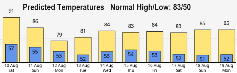
COOLER TEMPS? Some good news! Beginning Monday, we should be done with excessively hot and much above normal high temperatures (based on what I see with current long range data). With our fingers crossed, "relatively" cooler (around normal) temps should stick around through the end of the month. In fact, light showers may pop into the forecast at times after Aug 17. So, another heatwave is unlikely Monday through the end of the month! Normal high/low is 83/50. Highs Monday through all of next week (and into the following weekend) will mostly vary between the upper 70's and low 80's with maybe an 84/85 sneaking in here and there. Lows will be 47-54.
FIRES/SMOKE: Varying amounts of smoke from regional fires will be present over the next few days and will affect the air quality. Cottage Grove IS NOT going to burn down! The fires to our east currently pose no threat here! A rapidly spreading fire needs strong winds blowing from a favorable direction (particularly from the east) and an extremely low humidity (not expected over the next 7-14 days). Over the next 10 days, there's little risk for a significant wildland fire here. The risk just east of the Cascades is slightly higher, but still generally small. The Fire Danger Rating in Cottage Grove is at HIGH but varies at HIGH to EXTREME across the region.
FALL/WINTER OUTLOOK: Very preliminary, La Nina is taking longer than expected to kick in but should become official sometime between late Sept and mid or late Oct. There's an extremely small chance that La Nina may not even form at all. Early data coming in suggests that Sept/Oct may be drier than normal, which may extend into Nov. At this time, odds lean towards near normal to above normal precipitation for Dec/Jan/Feb (not set in stone, lots of variables come into play). Right now, there's no strong pointers either way for a much colder or much warmer winter. The ultimate strength of La Nina (and other factors) will play a big part in precipitation and possibly temperature trends Dec-Mar.