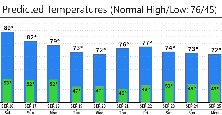
Hot today and Saturday (highs around 90°). Sunday will still be warm, but will be the start of a cooling trend as 2-3 weak low pressure systems' tail ends clip our area or pass just to the north. This will ensure that temperatures next week will be fall-like and around the seasonal normal of 76/45. In other words, chilly mornings and evenings can be expected next week. Winds will generally stay light at 10 mph or less, but there could be some breezy periods at times with gusts to 15 mph (especially some evenings next week).
RAIN? At this time it looks dry through Wednesday or Thursday. I'm keeping an eye on a low pressure system that may pass through Thursday evening or night into next Friday, but don't get your hopes up just yet. I'll talk about this possibility (or not) in a post on Sunday.
EL NINO conditions are present across specific portions of the Equatorial Pacific. El Nino DOES NOT come here, but, instead, causes large sways in the weather patterns due to its presence in certain parts of the Equatorial Pacific.
Think of El Nino and La Nina as a see-saw: El Nino is warmer than average sea-surface temperatures (SST's) in certain spots of the Equatorial Pacific and La Nina is the exact opposite - cooler than average SST's. When the see-saw is in the middle, "neutral" conditions exist (no El Nino or La Nina).
El Nino/La Nina have differing strengths. Each strength has different global impacts on the weather patterns.
El Nino & La Nina are sometimes enhanced by other global "oscillations" (see-saws) which is why we sometimes hear about unexpected enhanced rains, snows, drought, and temperatures at times in parts of the world (including here in the U.S.). One of these see-saw oscillations, the Madden-Julian Oscillation, can give a signal 7-10 days in advance of possible significant west-coast rain & snow. Highly experienced Meteorologists, such as myself, can usually give a heads up of a potentially wet and stormy phase ahead. This gives time for industries that are affected by heavy rains time to prepare. That said, nothing in the world of weather is absolute and sometimes these signals don't materialize as expected.
Anyway, if you have the weekend off, I hope that you get some R & R. If you got to work (like me having to work 7-days/wk in the winter), then I hope that things go smoothly with low stress.