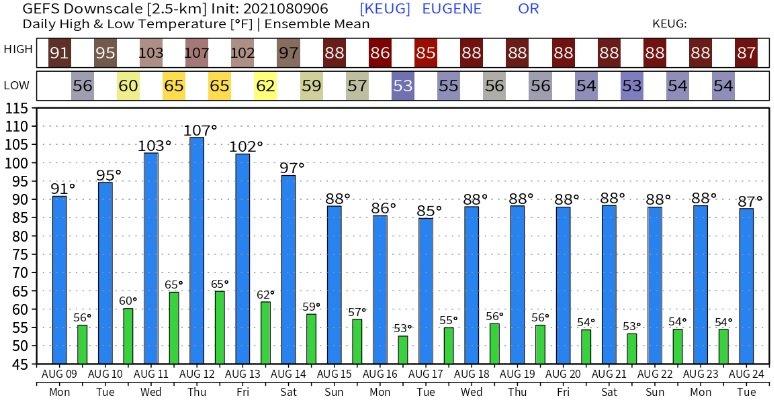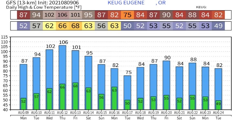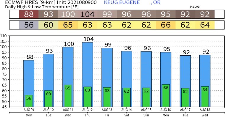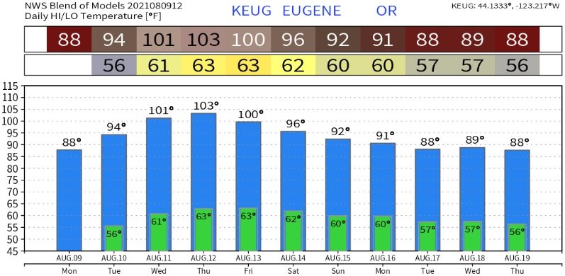
Strong high pressure will build into the region this week. Beginning Wednesday, and continuing through Saturday, hot high temperatures of 98-103 degrees can be expected. Evenings will be warmer than usual, with overnight lows will bottom out at around 60-65. Our seasonal average high/low temperatures are 86/52. But this really isn't shocking news, right? Especially since 40% of June, 58% of July, and 66% of August (so far) have experienced above normal high temperatures. Check out the website menu links for hot weather safety information, including tips for animals.
A cool down?
You may have noticed that the sun angle is changing and the days are getting shorter. A sign that fall is around the corner. In looking at data this morning, the heatwave should continue through Saturday. However, high pressure is expected to begin weakening and shift a little more east early in the weekend, so this could possibly shave a few degrees off Saturday's forecast temperatures. Although slightly more cooling is expected on Sunday, highs could still be in the low-mid 90's. It may not be until next Monday (Aug 16) when temperatures are more closer to "normal." It should be noted that strong summertime high pressure is often hard to break down so there's a small chance that "appreciable" cooling may not happen as currently forecast. Conversely, I do see signs that the jet stream and weather patterns are starting to respond to the increased sun angle which gives more credence that the low pressure system currently modeled to pass through Vancouver Island (Canada/BC) and possibly northern Washington on Saturday will be strong enough to weaken and start kicking the high pressure east.
Pets/Animals and heat
Remember your pets and animals! Ensure there's plenty of access to shade and fresh, cool water. Consider walking dogs in the morning or late evening close to sunset because sidewalk temperatures will likely reach 130-140 degrees during the afternoon. This can burn paws in under a minute! Never leave animals in a vehicle. Deadly temperatures can occur in just minutes, even with the windows partially rolled down. Don't be afraid to call the police to report animals locked in vehicles. Click here for the hot car/pavement temperature fact sheet for animals.
Below are some of the modeled temperature predictions. It's important to note that these are models and based on how things look right now (as of the time of this post).