Friday Weather Update (8:00am): A pair of strong storms will affect the region today through Tuesday.
WINDS: Can gust up to 25-30 mph at times through Sunday morning (45 mph in the foothills, 50+ in the mountains). HOWEVER, atmospheric processes may push winds down to the surface here in Cottage Grove and cause gusts to be 30-40 mph (at times) anytime between 11am today and 6:00am Saturday morning. Not a slam dunk for these stronger winds here but the possibility does exist, so be mindful of this.
RAIN: Heaviest rain occurs between 6pm this evening and 6:00am Saturday morning. During this period alone, we can see 1"-1.5" of rain. Next round of heavy rain occurs 6:00am-noon Sunday, adding another 3/4"-1". Outside of the above times, expect periods of rain / showers. Rivers will be running high and typical problem spots could have minor flooding (rivers here are not expected to flood).
SNOW LEVELS: Above 7000' through tonight, lowering to 4000' during the day on Saturday. Sunday starts off at 3000' and lowers to 1800' Sunday night. Varying at 1500-2000' Monday and Tuesday. Snow unlikely here in Cottage Grove.
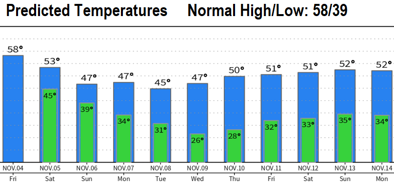
Wednesday through Friday looks dry at this time but cold (see temperature chart). In fact, except for the possibility of rain chances Saturday Nov 12, it's looking like an extended dry period might be in the works Wednesday of next week (Nov 9) through Nov 18. Lots of time for this to otherwise change though. You can always check out real-time weather conditions here: Cottage Grove Weather - https://grovewx.com