Be sure to scroll down to the end and see the picture that my Meteorologist friend in Florida sent me showing what fall looks like there! But first, here's the details on what we can expect over the next 10-days:
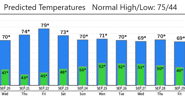
TEMPERATURES: High temperatures over the next 10-14 days will vary between the upper 60's and low and mid 70's with just a day or two in the upper 70's/near 80. Lows will mainly be in the low/mid 40's. This is the time of year where temps do roller coaster.
RAIN: Three low pressure systems will affect the area over the next 7-10 days. System #1 will only bring small rain chances (0.05" or less) early Tuesday morning. System #2 is looking like 1/10" or less Saturday into Sunday morning. Stronger system #3 is expected to bring rain to the region Sunday evening or night through Monday and Tuesday of next week. Depending on how this third system evolves, we could see 1/2" or more of total rainfall. I do need to note that there's still some uncertainty with this low pressure system that'll be affecting the entire region later Sunday through the early or middle portion of next week, so stay tuned.
SNOW LEVELS: mainly above 7000-8000', which means these systems won't be dropping our first big snow of the year.
WINDS: Breezes will mainly stay at 10 mph or less, however as each system passes through we could see some gusts to about 15 mph. That said, the Sunday night into next week storm (system #3) may be able to squeeze out a few gusts to 20-25 mph if things align just right.
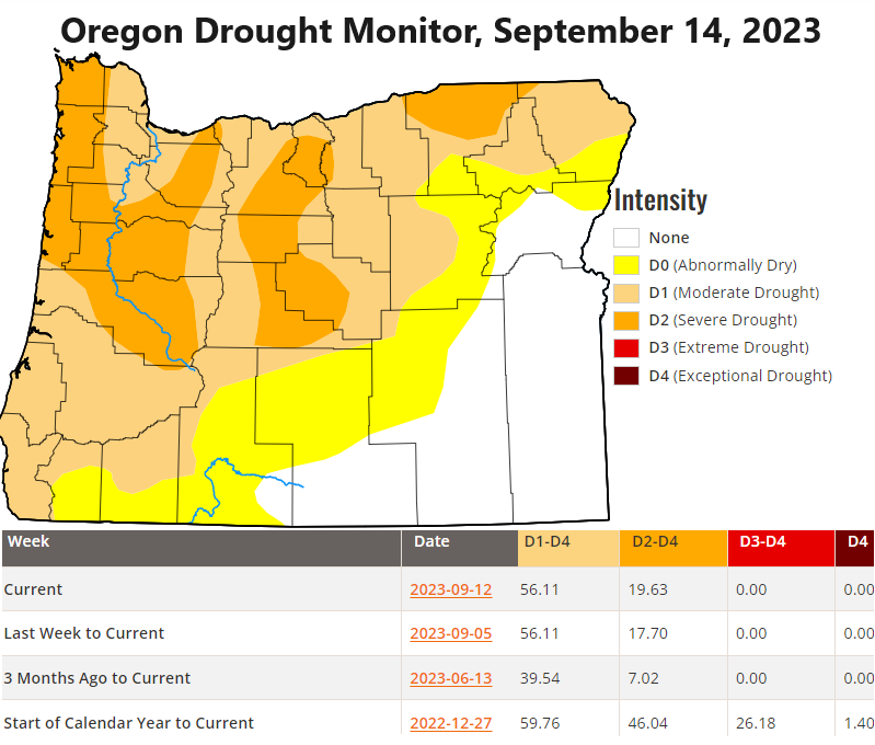
FIRES: Area fire danger rating dropped to Moderate at midnight this morning. These upcoming storms won't put out the regional fires that are burning, but the systems will help give firefighters the upper hand. Especially the storm coming in Sunday night into next week.
LOOKING AHEAD: Based on current data signals, odds favor wet and unsettled weather across the PacNW next week through around Oct 4. High pressure may build in around Oct 5 and switch us back into a dry pattern. But this isn't set in stone - we'll talk more about this possibility in future updates (next update on Friday or Saturday).
Subscribe to receive updates when we post weather and preparedness updates to our blog. You can elect immediate, daily, or weekly emails. We anticipate a fairly low volume - 3 to 5 posts per week.