Dusting still possible Monday morning; MUCH warmer next weekend!
April 1, 2023
Winter Storm Warning is NOT for Cottage Grove (it's for hills/mtns above 1500').
We got 0.80" of rain overnight! As of 11:00am today, we've recorded 25.48" of precipitation since the start of the water year on Oct 1. Normal to date is 35.07".
Scattered to numerous showers through Tuesday, with a small chance of a thunderstorm (maybe some hail?). Up to another 1" of total combined rainfall.
Breezy attimes, winds 20 mph or less.
Snow levels today above 2500', then 1500' Sunday. Sunday night/Monday morning snow levels may dip down to Cottage Grove (near 600-700') with just a dusting possible. Snow levels then vary at 1000-2000' the rest of Monday and on Tuesday.
Wednesday looks dry, then rain on Thursday with lingering showers into Friday. Not as cold of a storm so much higher snow levels.
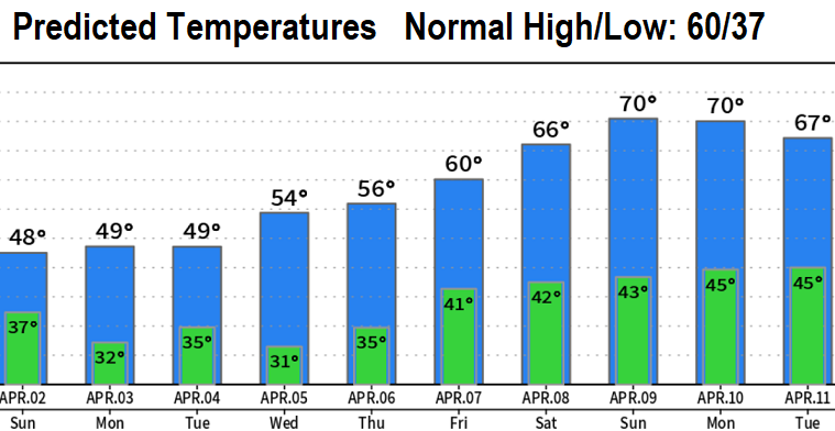
Significant warming trend at the end of next week into Easter Weekend with above normal temperatures for a change!
TEMPERATURE IMAGE ABOVE IS APRIL FOOLS JOKE! HERE'S THE REAL TEMPERATURES:
Subscribe to receive updates when we post weather and preparedness updates to our blog. You can elect immediate, daily, or weekly emails. We anticipate a fairly low volume - 3 to 5 posts per week.