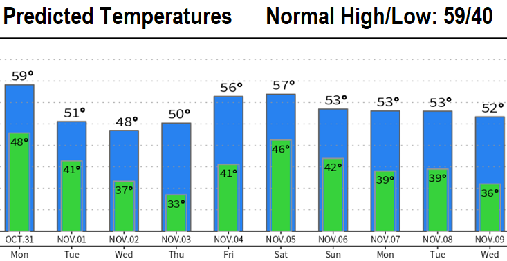
SUNDAY WEATHER UPDATE Generally dry and cloudy today (although can't rule out sprinkles or an isolated shower). Next storm system arrives on Monday with cooler temperatures and rain. Halloween will be wet with rain (mainly light) developing within the 4-hour window of 11:00am and 3:00pm. Rain is expected throughout Halloween evening with breezes mainly at 15 mph or less and chilly temperatures in the 50's (breezes will make it feel even colder). At this time, rain on Halloween doesn't look heavy - around 1/4" 3pm-8pm.Showers will continue on Tuesday and linger into Wednesday.
Total rainfall Monday through Wednesday: 1/2-3/4”. Dry on Thursday, but we'll add another 1/2” + from a another system that is expected to move through on Friday evening.
Winds: No strong wind concerns through Saturday, gusts should remain at 20 mph or less.
Snow levels: Monday 4500', Tuesday 3000-3500', Wednesday 3000', 6000'+ Friday-Saturday.
Frost possible Thursday morning, with early morning low temperatures of 31-34 likely.
Right now, it looks like another 2-3 low pressure systems may pass through Friday night into the early portion of the following week and could bring another 2"+ of rain (in other words, next weekend may be very wet). A dry period is then possible Nov 8-13, if the current data is correct. Anomalous high pressure in parts of the North Pacific Ocean continues to affect the Polar Jet Stream, which makes forecast accuracy problematic (especially beyond 4-5 days).