A cool down is still expected, but won't occur until Sunday or may possibly hold off until Monday. This is because high pressure over our region is strong and delaying the storm system that will bring cooler temperatures (system is currently in the Gulf of Alaska and slowly trekking south because it's being impeded by our high pressure). Therefore for today (Friday), expect varying amounts of high clouds. Smoke/haze "may" cause high temps today (Friday) to be in the low-mid 90's vs. the forecast 97-100 (we hit 101 on Wednesday and 103 yesterday). I emphasize "may" because we started the day out warmer due to some overnight cloud cover and it will depend on whether or not these clouds thin out, allowing more sunlight. There's also a very small chance of an isolated mountain thunderstorm. These clouds are coming from a "cut-off" low pressure system offshore near the CA/OR border. Air quality has taken a hit from the smoke in our area, varying from "moderate" to "unhealthy for sensitive groups." Winds are generally light-calm and mostly blowing from east to west, which is bringing smoke from the fires to our east into our area (mostly from the Middle Fork and Rough Patch Complex fires).
Saturday "may" have less clouds and therefore more sunlight. Highs are expected to top out at 95-98. But that cut-off low pressure system near the CA/OR border could also cause winds to shift and start blowing from a westerly direction. If this occurs, it could bring a bit of marine air in and help push smoke away from us. Some uncertainty exists because that offshore system near the CA/OR border is "cut-off" from the jet stream and wobbling around with a mind of its own. Therefore, a few different scenarios can play out (warmer, cooler, or the same as today).
Sunday, the Gulf of Alaska storm system approaches Vancouver Island (BC) and will finally begin kicking our high pressure eastward. Highs should lower to 90-94 and some high clouds will pass overhead. There's a chance that high temps could be 87-91 if there's a strong enough westerly breeze to bring more marine air in than what's currently expected.
Monday and Tuesday's high temperatures (around the mid 80's) are expected to be closer to our normal of 85. This will be compliments of that weak low pressure system affecting Vancouver Island and northern Washington. No rain for us, unfortunately. Just relatively cooler temperatures.
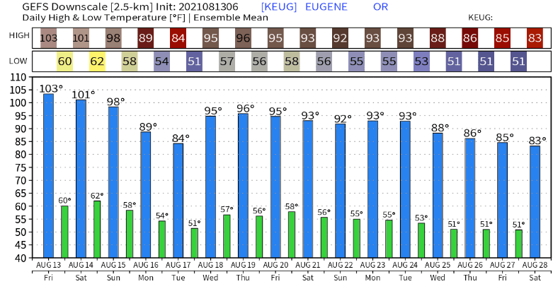
Middle and later next week, temperatures are expected to warm. How much warming occurs is still questionable at this point because data is on the fence as to whether strong high pressure builds back in or high pressure is weaker with perhaps a couple of ripples in the flow to keep temperatures in check. We'll talk more about this with a post on Sunday evening or Monday morning. Until then, here's a couple of the model-predicted temperatures:

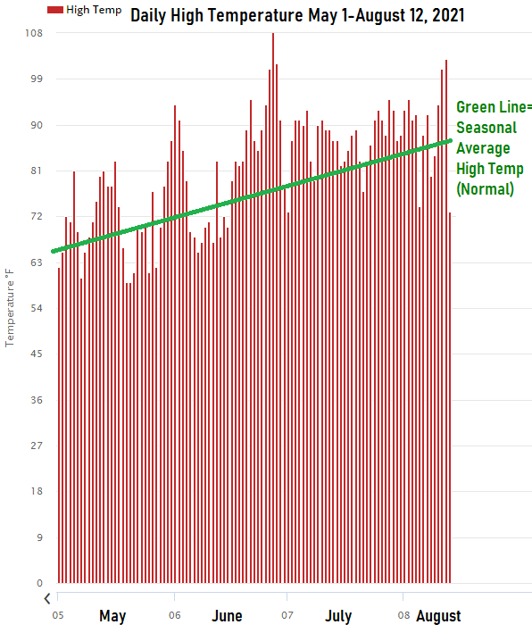
Hot Summer?
Since May 1 and through August 12, high temperatures have been mostly running above seasonal averages. I'm sure many of you would agree that this summer has been just plain out hot! We've had a handful of days where temperatures reached 100 degrees or more (let's not forget that day in June where we nearly reached 110 degrees).