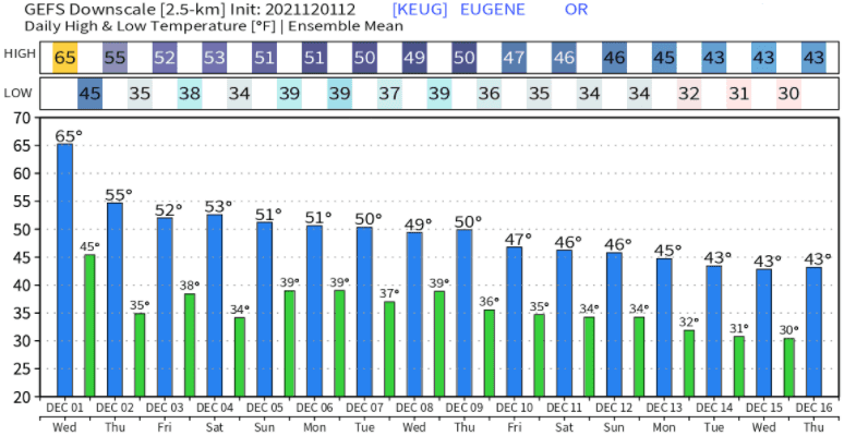
Wednesday Dec 1, 2021 Update: I'm sure you've been enjoying our "balmy" weather, but that will soon change. Except for an isolated shower or sprinkles Saturday afternoon, no rain is expected through Sunday. High temperatures Thursday through Sunday will drop into the low-mid 50's with lows near 34-39. Light, mainly northerly, winds through Friday. Saturday could be a little breezy with some wind gusts up to 15-20 mph.
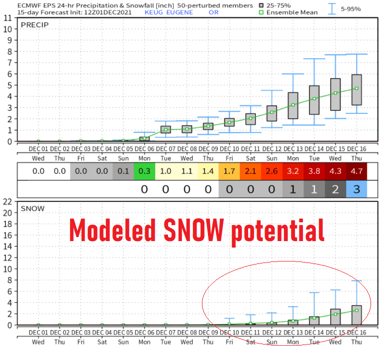
Monday: A series of low pressure systems are expected to pass through the region beginning early Monday morning and continuing through the middle of the month. Rainfall with Monday's storm looks to be around 3/4"-1". This isn't a particularly windy storm, so we'll probably only see a few southerly gusts to 20 mph or so. Snow levels on Monday will start off above 6000' then lower to 5000' during the late afternoon.
Wednesday Dec 8: Rain will develop during the morning, but this system appears lacking in moisture, so around 1/10" of rainfall looks like a good bet right now. No wind issues, snow levels near 4000'.
Thursday Dec 9: Rain should move in during the afternoon and continue through Friday morning. Still some uncertainties. Preliminarily, snow levels could be around 3000-4000'. Southerly wind gusts will probably stay under 25 mph, as this doesn't look like a windy storm. Total rainfall Thursday afternoon through Friday morning will likely be around 1/2-3/4".
Sat Dec 11 - Wed Dec 15: I'm watching this time period closely. Data is signaling that a strong and cold low pressure system may affect the area with potentially low snow levels on Saturday (Dec 11), followed by another colder system on Sun Dec 12 or Mon Dec 13 that could possibly drop snow levels to around 1000'. This is all still preliminary and I want to emphasize it is impossible to predict lowland snow this far into the future. If data continues to maintain the strong strength of the low pressure system on Sat Dec 11, strong winds could affect our area.
I avoid hyping because it gets us nowhere, and it's nearly impossible to predict snow beyond 3-days across the lowland areas. That said, there's little doubt that Dec 12-17, cooler air will come in and low pressure systems will become colder. Therefore, most models and their ensembles strongly hint at lowland snow possibilities sometime between Dec 12 and Dec 17. Think of ensembles as dozens of different modeled solutions for the weather pattern at a given time. The more that the ensembles have a similar outcome, better confidence exists with the favored prediction. By no means is this a slam dunk and it's low accuracy this far out but with a little more optimism since many model ensembles are on board for at least some potential for lowland snow. Next post is expected to be on Saturday Dec 4 and I'll be sure to update you on the snow potential. Here's one of the many ensemble's predicted snow:
Most models are similar to these projected temperatures. The takeaway message is that we'll trend cooler.