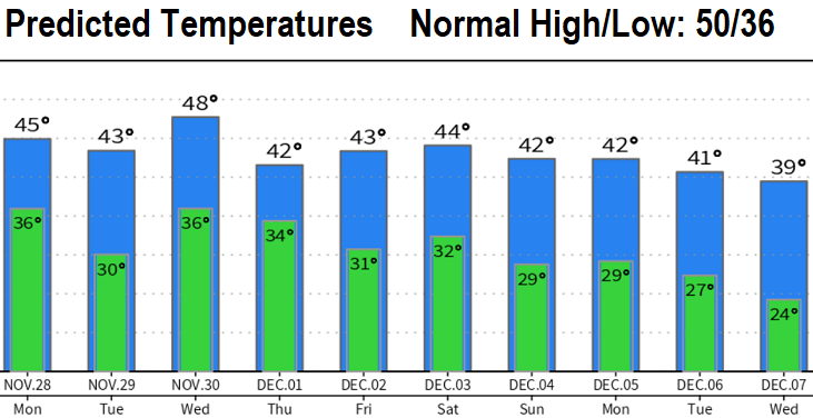
Do you think it will snow? Over the next 10-days, about four storm systems will affect the area. The first one is affecting us now - snow levels 2500-3000' today (Sunday). Rest of this week's snow levels below.
RAIN/SNOW: Between now and Saturday, we can see a combined total of 1-3" of rain with 3 to possibly 5 feet of total snow at the higher elevations of the Cascades. At 2500' 6-12" of total snow possible through Saturday. Driest time period this week Monday evening through Tuesday morning.
WIND: It can get a little windy late Tuesday night through Wednesday morning with gusts up to 30 mph. Possibly again on Saturday. This is not strong enough to cause any damage, especially since most leaves have now fallen off the trees. In between these days, winds are expected to stay at 20 mph or less.
Best chances for snow in CG looks to be Wednesday night through Friday morning. That said, if conditions align just right, it's not out of the question to see some flakes here in CG outside of the above listed time period. Snow predictions are most accurate within 24-48 hours, I'm sure apps are going haywire and showing snow here much of the week.
SNOW LEVELS (as of the time of this post):