You probably noticed less marine clouds this morning, which means more sun and warmer high temperatures into the mid 80's to low 90's. This will continue through the weekend. Normal high is near 82. I've attached one of the computer model's temperature predictions. Not exact, but it gives an idea on what things *may* look like over the next couple of weeks. Check out the latest Drought Monitor and the satellite image which clearly shows two large fires burning in Oregon. The Jack Fire east of Roseburg (currently near 4300 acres) and the massive Bootleg Fire a little northeast of Klamath Falls (nearing 17,000 acres). When you play the Satellite Image, it starts from about 12:30pm yesterday and runs to 8:45 this morning. Note the smoke yesterday was being blown to the east but after sunrise this morning it's now being blown to the west because the inland winds have shifted due to high pressure strengthening (as noticed by the absence of marine clouds here this morning). Therefore, it's possible a little smoke may move into our area from the Jack Fire but at this time I'm not expecting the air quality getting any worse than "moderate." As of the time of this post, the air quality was "good." Fire Danger Rating continues at HIGH.
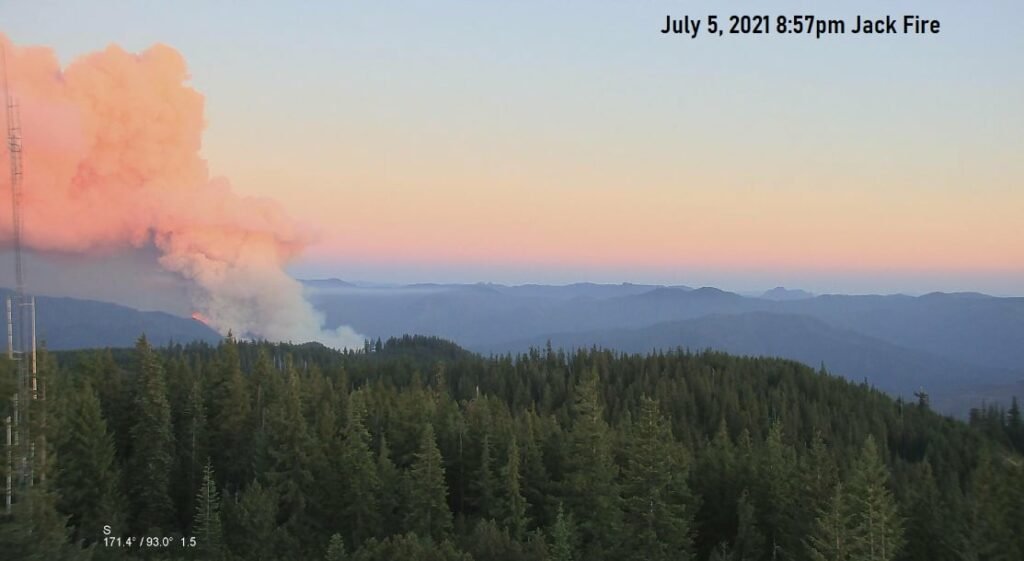
Check out the smoke plume from the Jack Fire in the visible satellite image (started at approx 5:00pm on July 5). Also take a look at yesterday evening's webcam photo of the fire. This fire is not a threat to our local area and is well east of Roseburg. At this time, the general low level wind flow is expected to be somewhat coming out of the west over the next couple of days. This should keep smoke out of our area (unless winds shift) and will give us a brief cool down before we heat back up at the end of the week and weekend. Our air quality is currently "good"
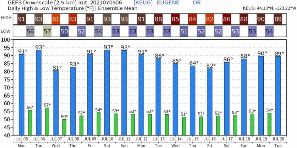
Now that we're past July 4th, next up on the big event radar is Bohemia Mining Days (BMD) on July 17-18. Computer model accuracy beyond 5-days drops significantly so take the pictured model predictions with a grain of salt. When I look at what the models show between the surface and 18,000 feet up, there's strong indications that we'll be going through several rounds of anomalously strong high pressure over the next two weeks. Our high temps fluctuate *mostly* between the mid 80's to low 90's (80-85 this Wednesday for Concerts in the Park 6:30pm). Normal is near 80. Preliminary hints are that BMD may have high temps in the mid-80's. No rain in sight. Fire danger is HIGH.