Pesky weak low pressure system = a few light showers through Saturday (emphasize light, 1/4" or less). Dry Sunday-Monday. Breezes also light, 10 mph or less with just a gust or two to 15 mph. Another weak system may cause a couple of light showers Tuesday. Wednesday-Thursday looks dry then light shower chances return NEXT Friday into the following weekend (currently doesn't look like anything significant).
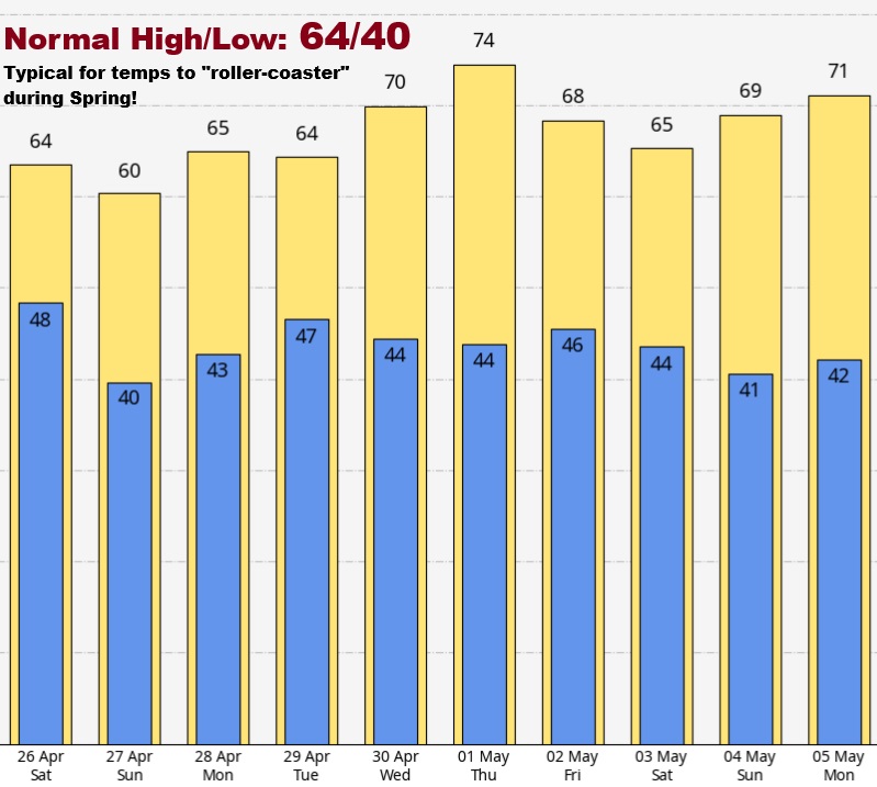
Overall, way more dry than wet next 14-days (through May 10) with no significant storm systems nor strong winds seen.
Odds for the whole month of May lean towards below normal rainfall and above normal temperatures. Same for June. Remember, these are odds, not 100%, and doesn't mean that it will be hot with heatwaves.
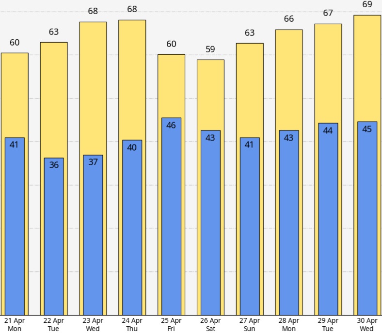
Happy Easter! Dry through Thursday but temperatures will roller coaster (typical during spring). Coldest mornings will be Tuesday + Wednesday morning with lows mid 30's (see 10-day temperature map). Normal high/low: 64/39. At this time it looks like a low pressure system will bring around 1/3" of showers next Friday through next Sunday and it will be a little cooler. More details in the next post on Tuesday.
Continued dry / nice through Easter weekend and the middle of next week but Sat-Mon a weak/dry low pressure system will clip the area so it will be cooler with some passing clouds (highs 60-65 instead of the 70's that we're seeing). Morning lows mostly mid-upper 30's. Normal high/low: 63/39. Approx temperatures on Easter Sunday: 40° at 8am, 55° at noon, 60° at 4pm.
Starting around Friday April 25, a weather pattern change may occur with a return of spring showers. Some uncertainties but currently looks like typical mid-spring weather and nothing more.
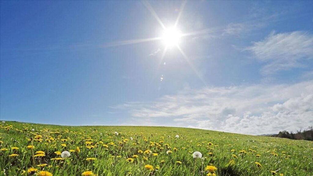
Doesn't it feel good to see more of that bright orange ball in the sky? Today (Saturday April 12) through Easter Sunday (next weekend April 20): lots of sunny days with some passing clouds and light breezes at times (today, Saturday, breezes to near 20 mph possible). Normal high/low is 62/38. Below normal today then a noticeable warm-up tomorrow (Sunday) with above normal temps then continuing through NEXT Saturday. Easter Sunday looks to cool to near normal temps, some clouds, and possible isolated light showers after 5pm.
No significant weather seen over the next 10-14 days (through April 26).
Tuesday April 1: It's April Fools' Day but no fooling that you're AWESOME!
No significant weather over the next 7-10 days. Just very light showers at times through Wednesday (less than 1/4" TOTAL) with light breezes. Cold nights through Thursday - lows low-mid 30's with daytime temps in the 50's (around 60 Thursday). Normal high/low: 60/37.
Dry with lots of sun Thursday through Saturday. Much warmer Friday-Saturday with highs 70-75, lows 35-40.
Light showers return Sunday-Monday, just looks like another 1/4" of rainfall. Temps cool to around normal. Middle of next week into the following weekend (Wed Apr 9 - Sat Apr 12) currently looks dry and warmer. Maybe some showers Sun Apr 13. Easter Sunday (Apr 20): NO WAY TO TELL right now whether it will be dry but I'm currently "leaning" towards showers based on the then possible pattern and current data (low accuracy this far out).
It's Saturday (Mar 29)! Dry today with lots of sun, rain/showers develop Sunday after 11am-1pm and continue through Monday with mainly light showers on Tuesday to just after sunset. Can't rule out an isolated thunderstorm. Strong winds not expected with gusts staying at 15-25 mph. Total rainfall Sun-Tue 3/4-1". Normal high/low 60/37. We'll be around normal today-Sunday then below Monday through Thursday.
Some isolated light showers possible Wednesday and Thursday, then DRY with lots of SUNSHINE expected Friday through next weekend and possibly into early the following week (right now Fri Apr 4 through Wed Apr 9 looks dry). Near normal temperatures Friday then above next weekend! This is how it looks as of the time of this writing.
Scroll below to see pictures from yesterday's "tornadoes," (wink) also read "SEVERE WEATHER" section below.
Today-Friday: Expect 0.75-1.25" total rainfall from rain/showers
Breezy at times with 20-30 mph wind gusts possible (today-Friday)
Very small chance of just a regular typical Oregon thunderstorm
Saturday looks dry but can't rule out an isolated light shower afternoon
Sunday morning mainly dry then light showers afternoon through Monday
Lingering shower or two Tuesday then uncertainties Wed-Fri
NO concerns for "SEVERE" weather / "tornadoes" next 10-days!
SEVERE WEATHER YESTERDAY (Wednesday):
As what was stressed in posts here, such was unlikely and the threat ridiculously small.
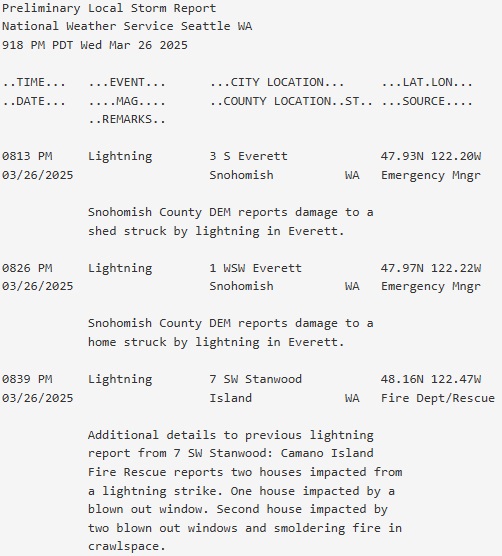
THERE WERE NO SEVERE WEATHER REPORTS anywhere in Oregon yesterday! Not one single "severe" thunderstorm, no large hail, no strong winds over 57 mph, no funnel clouds, and certainly no tornadoes. In Washington, lightning struck two houses and one shed (see NWS Seattle's "Preliminary Local Storm Report" below).
Across the state, there were about 7-10 non-severe, regular thunderstorms.
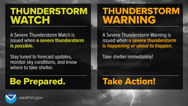
The Storm Prediction Center did issue a "Severe Thunderstorm Watch" from 3:10pm-9:00pm from about Harrisburg northward to around Tacoma, WA but no severe thunderstorms occurred.
Yesterday was unnecessarily hyped up (not in this group) and scared a lot of people. Yes, conditions could have become favorable for isolated severe thunderstorms and a supercell. As an expert, I saw atmospheric obstacles in place that prevented severe weather and think my colleagues didn't take such into consideration. If we were in the middle part of the country, then yes, a severe weather outbreak would have been likely. But even in "tornado alley," severe thunderstorm watches often have "bust" days where nothing occurs.
No major changes to yesterday's post about today's thunderstorm chances. Looks like 1:00pm-7:00pm has the highest chances of a t-storm with 3pm-6pm the bullseye. Diehard thunderstorm fans are extremely excited about today's possibility so that's why you're seeing social media erupt with talk about severe thunderstorms, hail, tornadoes.
PUTTING THINGS INTO PERSPECTIVE: Tornado Threat is ridiculously low (just 2% of one occurring within 25 miles of here). Hail threat over 1" is 15% within 25 miles of here. Wind threat of 58 mph or higher is 5% within 25 miles of here.
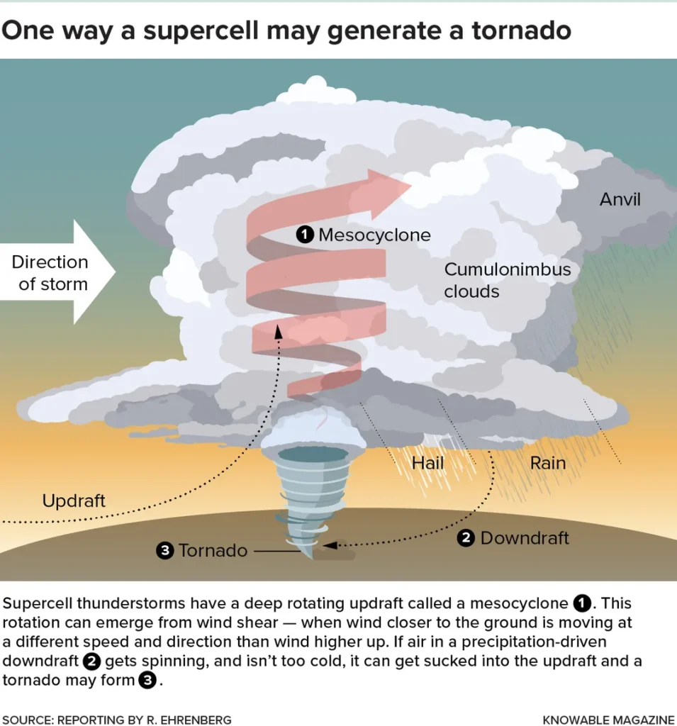
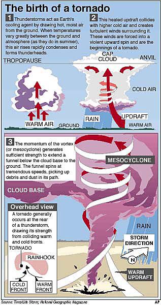
We DON'T get tornadoes here like what you see on TV. That all happens east of the Rocky Mountains and especially in the Midwest, Plains, and South. People in Kansas, Oklahoma, Texas LAUGH when they see pictures of an Oregon tornado (they really do). See attached images on how a tornado forms.
Since 1950 (when tornado records began): 133 tornadoes have been recorded in Oregon. This averages out to about two per year and every year there has been at least one tornado recorded so this is nothing new. No deaths have been recorded in Oregon from a tornado.
Regional "severe" thunderstorm threat IS rare here and that's why you're seeing lots of hype. Weather enthusiasts are excited that they might see a thunderstorm or even have an opportunity to amateur storm chase. I don't blame them (see #4).
Bathroom Reading: In the late 1990's, I was a Student Intern at the National Weather Service while studying Meteorology. Every year I drove out to Oklahoma and spent the entire month of May studying the atmosphere / storm chasing (May is when most tornadoes occur there). Storm Chasers literally lived just for days when a severe thunderstorm potential exists. In the morning, would stop into local National Weather Service offices to get the latest data from balloon launches then drive to the "prime" location where instability was greatest in hopes of seeing a tornado. Most days were a "bust" meaning that either Mother Nature didn't cooperate and it would only be very humid and hot or would just have a basic thunderstorm with nothing to write home about. But those days were also fun because we'd eat at different restaurants and meet people from different areas. The next day we would start the process all over again by heading to the NWS for the latest data after breakfast. BACK THEN there was limited data on the internet and you had to plug your computer into a landline phone to download what little data existed (which took an hour). There was no wifi and cell phones were rare, didn't have a screen with internet, no text.
No need to worry; let's talk sense and perspective:
Isolated to possibly scattered thunderstorms expected Wednesday, very isolated thunderstorms Thursday.
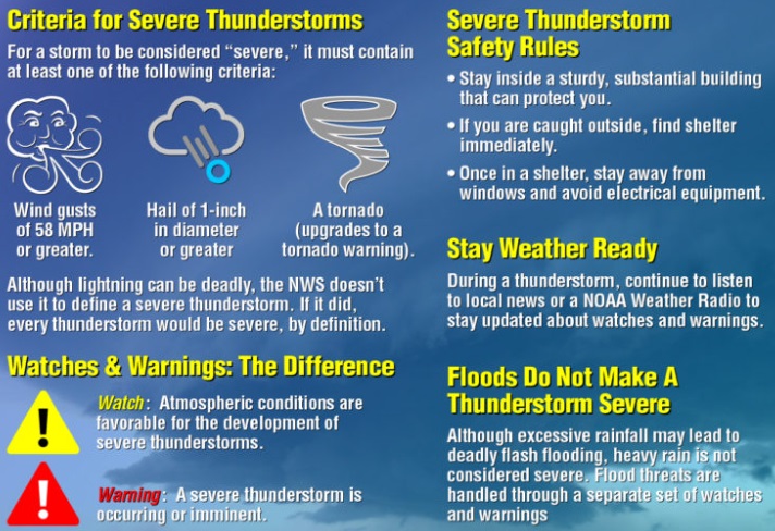
Under the right circumstances, a few thunderstorms on Wednesday have a very small risk of becoming "severe." Severe thunderstorms, by definition: capable of producing 58 mph or greater winds, 1" or larger hail, funnel cloud or brief tornado. In the entire U.S., just 5% of thunderstorms become severe and of all "severe" thunderstorms, 1% produce a tornado. A "supercell thunderstorm" (very very very rare in Oregon, more common east of Rockies), only makeup a small percentage of "severe" thunderstorms, historically produce a tornado about 20% of the time. The majority of severe thunderstorms have strong wind gusts with small to medium sized hail.
Greatest risk for a "severe" thunderstorm is Wednesday 1:00pm-5:00pm and mainly within the Willamette Valley (including Cottage Grove).
There is no way to predict exactly where thunderstorms will form. Putting things into perspective, there's about a 20-40% chance of a thunderstorm occurring within 25 miles of any one point on Wednesday. Within this, the severe thunderstorm risk of 1" or larger hail is 15% within 25-miles of any point and just a 2% risk of a small tornado within 25-miles of any point.
Total combined rainfall Wed-Thur (via showers) is less than 1/2" (higher if t-storm). Winds under 20 mph Wednesday (stronger gusts if t-storm) then 15-30 mph Thursday.
Friday will have around 1/2" of rain/showers and 15-30 mph wind gusts.
What's that bright orange ball in sky? Plenty of it today and Tuesday with high temps in the 70's! Showers and scattered thunderstorms Wednesday / Thursday with 15-25 mph wind gusts. Showers Friday, dry Saturday (right now), rain / showers Sunday into the following Monday (Mar 31).