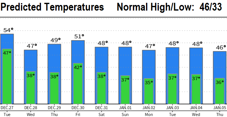
A strong and windy storm system will affect the region through Tuesday, dropping up to 2" of rain. Additional storms pass through Wednesday night through Friday. At this time New Year's Eve looks dry from the afternoon through New Year's Day.
WINDS: Up to 20 mph to midnight, then up to 35 mph to 8:00am Tuesday, and up to 45 mph 8am-4pm (Tuesday). Strongest wind gusts look to occur 9am- 4pm Tuesday, then will gradually lessen Tuesday evening. Wednesday onward, winds should be 20 mph or less.
HAZARDS: Tree branches can break and with the soils saturated, some trees may topple (especially those that are weak, diseased, or have compromised roots). It's a good idea to secure outside objects that can be blown around by the winds (such as patio chairs, etc). Power outages may occur. Rivers, creeks, and streams will be running high. Some minor flooding possible.
RAINFALL: Rain develops today (Monday), but heavy rainfall occurs this evening through Tuesday afternoon. Total rainfall to 4pm on Tuesday looks to be 1.50-2". Then expect showers 4pm Tuesday through Wednesday (probably some breaks on Wednesday). Add another combined 1" or so from the storms on Thursday and Friday, and we may be recording a total of possibly near 4" by week's end.
SNOW: Snow levels start out today at above 7000' then lower on Tuesday to 4500' on Tuesday afternoon. Rest of the week looks like 4000-5500'. Over 5 feet of new snow is likely at the higher elevations.