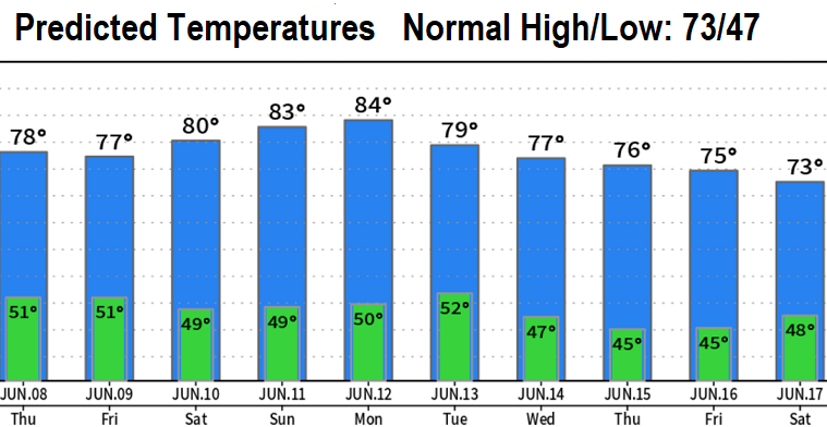

We hit 89° yesterday, and I'm sure you noticed it was muggy too! I wish I could say it was the hottest day of the year so far, but it wasn't (we hit 94° back on May 14 and 90° on May 15). A little cooler today; temperatures will roller coaster over the next 10-days. At this time, I don't see outrageously hot heat through the end of June. In fact, after June 15 temperatures look to be more cooler and hover right around normal (highs low 70's, lows upper 40's).
What's with all the humidity? An unusual pattern is in place with a low pressure system spinning over central/southern California and mini low pressure systems across the region. High pressure is just to our west. The "flow" pattern is from east to west, which is what's been bringing us hot temps, increased humidity, and mountain thunderstorms. This same pattern will generally continue through Friday or Saturday.
Today will be mostly cloudy to perhaps partly cloudy with a small chance of a shower or thunderstorm. Pretty similar on Thursday with probably a bit more sunshine; partly cloudy on Friday. We then get back to a more typical June pattern on Saturday as high pressure regains control of the region.

