Colder with low elevation Snow...

March 21, 2023

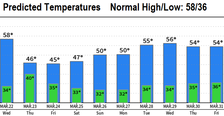
TUESDAY: We hit 60° today but much colder temperatures are on the way! Wednesday will only be a bit cooler than today with mainly scattered light showers across the area. A cold low pressure system will then send two waves of energy into the region Thursday through Saturday morning. Expect it to be much colder with unseasonably low snow levels (possibly down to 600' at times).

  • Best chances for a rain/snow mix or a light dusting is Thursday night into Friday morning and Friday night into Saturday morning. However, any heavier showers during the day could drop ice pellets or a brief rain/snow mix.
  • A chance of thunderstorms will exist, with the possibility of hail.
  • Winds can gust up to around 25 mph on Thurs/Fri.
  • Total rainfall Wed-Sat looks to be 2/3-1". FYI, we're running behind by a little over 11" and will not make this up by summer.
  • Cascades: Could see almost a foot at 2000' and up to two feet higher up (heaviest Thurs-Sat).
  • 77% of Oregon is in a drought. Statewide snowpack is 115-148% of average, so at least that's some good news.
  • It's not you: temperatures have been well below normal the past month! Same with rainfall.
  • For April, odds favor near normal temperatures and near normal precipitation (preliminary).
Back to our Blog
Subscribe to our blog!
Subscribe to receive updates when we post weather and preparedness updates to our blog. You can elect immediate, daily, or weekly emails. We anticipate a fairly low volume - 3 to 5 posts per week.


Copyright ©2024 grovewx.com