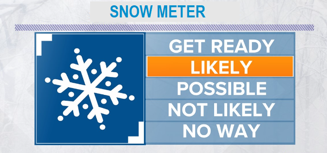
Can't rule out a rain/snow mix or a dusting today.
Tonight into Monday morning, low chance for a dusting to 1" or so of snow as the next storm arrives.
Monday's storm system is expected to stall near Astoria and spin waves of energy and moisture into the region through Tuesday. Exactly where the heaviest waves of moisture will end up is anyone's guess right now. It possible that we can get the snow that Portland got with last week's event or we can just see a dusting.
Monday night through Tuesday night, fair to good chance for 1-4" of snow. Best chances for accumulating snow is Monday night into Tuesday morning and again Tuesday night into early Wednesday morning. During the day on Tuesday, we may get a rain/snow mix or a dusting that could quickly melt. The night and morning hours have the best chances for snow to accumulate due to the expected freezing or below freezing temperatures.
WIND: Breezy at times, with gusts up to 30 mph tonight through Monday.
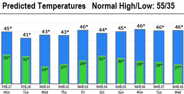
TEMPERATURES: See chart below.
TOTAL RAINFALL: 1" or so through Wednesday morning. As of 11:59pm Saturday night, we've recorded 18.19" of precipitation since the start of the water year on Oct 1. Normal to date is 29.36" (62% of normal). Our region of the snowpack is at 94%. March is expected to have near to slightly above normal precipitation, but it is highly unlikely that we'll make up the 10"+ deficit by summer. This means worsening drought (77% of Oregon is in a drought, up from 70% a week ago).
Subscribe to receive updates when we post weather and preparedness updates to our blog. You can elect immediate, daily, or weekly emails. We anticipate a fairly low volume - 3 to 5 posts per week.